File:Abkhazia summary map.png
No higher resolution available.
Abkhazia_summary_map.png (250 × 185 pixels, file size: 26 KB, MIME type: image/png)
Captions
Captions
Add a one-line explanation of what this file represents
Summary edit
| Description |
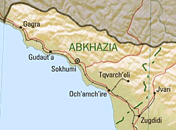
English: Summary map of Abkhazia as of 1999. |
| Date | |
| Source | Cropped version of Georgia (Shaded Relief) 1999 from Perry-Castañeda Library Map Collection: Republic of Georgia Maps |
| Author | U.S. Central Intelligence Agency |
| Permission (Reusing this file) |
Public domain |
Licensing edit
| This image is a work of a Central Intelligence Agency employee, taken or made as part of that person's official duties. As a Work of the United States Government, this image or media is in the public domain in the United States.
|

|
nl:Afbeelding:Abkhazia summary map.png
File history
Click on a date/time to view the file as it appeared at that time.
| Date/Time | Thumbnail | Dimensions | User | Comment | |
|---|---|---|---|---|---|
| current | 18:46, 11 January 2006 | | 250 × 185 (26 KB) | Maksim (talk | contribs) | La bildo estas kopiita de wikipedia:nl. La originala priskribo estas: Bron: en:Image:Abkhazia_summary_map.png {{PD}} categorie:Kaart {| border="1" ! date/time || username || edit summary |---- | 22 jun 2005 13:09 || [[:nl:Gebruiker:Michiel1972 |
You cannot overwrite this file.
File usage on Commons
The following page uses this file:
File usage on other wikis
The following other wikis use this file:
- Usage on ca.wikipedia.org
- Usage on cs.wikipedia.org
- Usage on hu.wikipedia.org
- Usage on it.wikipedia.org
- Usage on nl.wikipedia.org
- Usage on pl.wikipedia.org
- Usage on sv.wikipedia.org
- Usage on uk.wikipedia.org