File:Abraham Wolfgang Küfner.JPG

Original file (2,456 × 2,714 pixels, file size: 442 KB, MIME type: image/jpeg)
Captions
Captions
Summary edit
| Camera location | | View this and other nearby images on: OpenStreetMap |
|---|
| Description |
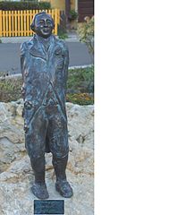
Deutsch: Er wurde am 3. Februar 1760 im Hause der Badestube zu Betzenstein als Sohn des Baders, Chirurg und Accoucheurs (=Geburtshelfer) Conrad Küfner geboren. (Schreibweise zeitweise auch »Küffner«)
Die Einschreibung Küfners als Student an der Universität Altdorf (bei Nürnberg) im Jahr 1779. Er wechselte am 14. April 1781 zur Universität Erlangen und wird als Mathematikstudent eingeschreiben. Mit diesem Talent konnte er sich am 23. Mai 1786 in der Reichsstadt Nürnberg als »Mignateur«, d.h. Miniaturmaler das Bürgerrecht erwerben. Am 1. August 1786 wird er mit Anna Maria, Tochter des Baders und Wundarztes Johann Carl Friedrich Aichele getraut, der auch Feldscheer in der Burger-Cavallerie war. Aus der Ehe gingen sechs Kinder hervor. Den Wohnort Nürnberg verlegte er mit dem Kauf des Zeidelmuttergutes am 23. August 1791 nach Feucht bei Nürnberg, das er aber 1792 wieder veräußerte. Zuletzt lebte er in Ingolstadt an der Donau, wo er am 5. Oktober 1817 an Schlagfluss verstarb.Eines der wichtigen Details auf der Statue ist das: Selbstbildnis Albrecht Dürers. Ein anderes ist: die sechs Kinder mit Ehefrau Anna Maria. Ein weiteres: die Zauberflöte. This is a photograph of an architectural monument. It is on the list of cultural monuments of Bayern, no. 0. |
| Date | |
| Source | Own work |
| Author | P.Reinhardt |
Licensing edit
- You are free:
- to share – to copy, distribute and transmit the work
- to remix – to adapt the work
- Under the following conditions:
- attribution – You must give appropriate credit, provide a link to the license, and indicate if changes were made. You may do so in any reasonable manner, but not in any way that suggests the licensor endorses you or your use.
- share alike – If you remix, transform, or build upon the material, you must distribute your contributions under the same or compatible license as the original.

|
This image was uploaded as part of Wiki Loves Monuments 2012.
|
File history
Click on a date/time to view the file as it appeared at that time.
| Date/Time | Thumbnail | Dimensions | User | Comment | |
|---|---|---|---|---|---|
| current | 16:27, 12 September 2012 | | 2,456 × 2,714 (442 KB) | P.Reinhardt (talk | contribs) | User created page with UploadWizard |
You cannot overwrite this file.
File usage on Commons
There are no pages that use this file.