File:Accord de délimitation des frontières entre la France et la Nouvelle-Zélande.png
No higher resolution available.
Accord_de_délimitation_des_frontières_entre_la_France_et_la_Nouvelle-Zélande.png (770 × 417 pixels, file size: 89 KB, MIME type: image/png)
Captions
Captions
Add a one-line explanation of what this file represents

|
This map image could be re-created using vector graphics as an SVG file. This has several advantages; see Commons:Media for cleanup for more information. If an SVG form of this image is available, please upload it and afterwards replace this template with
{{vector version available|new image name}}.
It is recommended to name the SVG file “Accord de délimitation des frontières entre la France et la Nouvelle-Zélande.svg”—then the template Vector version available (or Vva) does not need the new image name parameter. |
Summary edit
| Description |
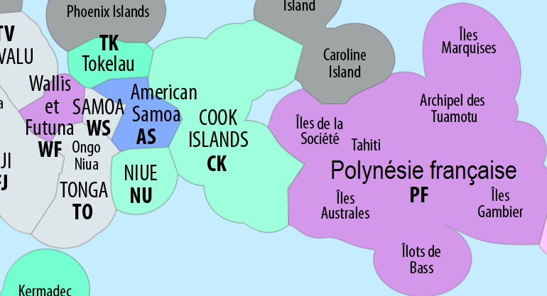
Deutsch: Ausschließliche Wirtschaftszonen (EEZ) im Pazifischen Ozean
English: Exclusive Economic Zones (EEZ) of the Pacific Ocean
Français : Zones économiques exclusives (ZEE) de l'océan Pacifique
Euskara: Ozeano Bareko Ekonomia-eremu esklusiboak (EEE) |
| Date | see file history |
| Source | Own work using: this map by B1mbo |
| Author | Maximilian Dörrbecker (Chumwa) |
| Permission (Reusing this file) |
I, the copyright holder of this work, hereby publish it under the following license: This file is licensed under the Creative Commons Attribution-Share Alike 2.5 Generic license.
Sie dürfen das Bild zu den folgenden Bedingungen nutzen:
|
| Other versions |
|


File history
Click on a date/time to view the file as it appeared at that time.
| Date/Time | Thumbnail | Dimensions | User | Comment | |
|---|---|---|---|---|---|
| current | 23:16, 30 December 2022 | | 770 × 417 (89 KB) | Edoirefaitdel'art (talk | contribs) | File:Map of the Territorial Waters of the Pacific Ocean.png cropped 75 % horizontally, 75 % vertically using CropTool with precise mode. |
You cannot overwrite this file.
File usage on Commons
There are no pages that use this file.
File usage on other wikis
The following other wikis use this file:
- Usage on fr.wikipedia.org