File:Acherontia atropos distribution map.png

Size of this preview: 800 × 353 pixels. Other resolutions: 320 × 141 pixels | 640 × 283 pixels | 1,024 × 452 pixels | 1,280 × 565 pixels | 2,604 × 1,150 pixels.
Original file (2,604 × 1,150 pixels, file size: 996 KB, MIME type: image/png)
Captions
Captions
Add a one-line explanation of what this file represents
Summary edit
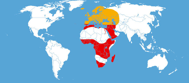
| Description |
Deutsch: Verbreitungskarte des Totenkopfschwärmers;
Rot: ständiges Vorkommen; Orange: Vorkommen im Sommer möglich English: Distribution map of Acherontia atropos;
red: all year distribution; orange: summer distribution possible
|
||
| Date | |||
| Source |
|
||
| Author | NordNordWest | ||
| Permission (Reusing this file) |
|
||
| Other versions | Derivative works of this file: Acherontia atropos distribution map cutted.png |

File history
Click on a date/time to view the file as it appeared at that time.
| Date/Time | Thumbnail | Dimensions | User | Comment | |
|---|---|---|---|---|---|
| current | 21:10, 9 March 2018 | | 2,604 × 1,150 (996 KB) | NordNordWest (talk | contribs) | South Sudan |
| 14:16, 6 September 2009 |  | 2,604 × 1,150 (966 KB) | NordNordWest (talk | contribs) | ||
| 13:36, 6 September 2009 |  | 2,604 × 1,150 (966 KB) | NordNordWest (talk | contribs) | {{int:filedesc}} {{Information |Description=''Acherontia atropos'' {{de|Verbreitungskarte des Totenkopfschwärmers;<br >Rot: ständiges Vorkommen, Orange: Vorkommen im Sommer möglich}} {{en|Distribution map of [[:en:Achero |
You cannot overwrite this file.
File usage on Commons
The following 4 pages use this file:
File usage on other wikis
The following other wikis use this file:
- Usage on af.wikipedia.org
- Usage on arz.wikipedia.org
- Usage on ast.wikipedia.org
- Usage on bg.wikipedia.org
- Usage on ceb.wikipedia.org
- Usage on cs.wikipedia.org
- Usage on cy.wikipedia.org
- Usage on da.wikipedia.org
- Usage on de.wikipedia.org
- Usage on en.wikipedia.org
- Usage on eo.wikipedia.org
- Usage on es.wikipedia.org
- Usage on eu.wikipedia.org
- Usage on fa.wikipedia.org
- Usage on fr.wikipedia.org
- Usage on id.wikipedia.org
- Usage on it.wikipedia.org
- Usage on kab.wikipedia.org
- Usage on kk.wikipedia.org
- Usage on pt.wikipedia.org
- Usage on sl.wikipedia.org
- Usage on sr.wikipedia.org
- Usage on sv.wikipedia.org
- Usage on uk.wikipedia.org
- Usage on vi.wikipedia.org
- Usage on www.wikidata.org
- Usage on zh.wikipedia.org