File:Adel volcanics.jpg

Size of this preview: 551 × 600 pixels. Other resolutions: 220 × 240 pixels | 441 × 480 pixels | 706 × 768 pixels | 941 × 1,024 pixels | 1,661 × 1,808 pixels.
Original file (1,661 × 1,808 pixels, file size: 689 KB, MIME type: image/jpeg)
Captions
Captions
Add a one-line explanation of what this file represents
Summary edit
| Description |
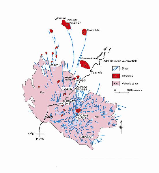
English: Simplified geologic map of the Adel Mountain volcanic field. From: Stephen S. Harlan, Lawrence W. Snee, Mitchell W. Reynolds, Harald H. Mehnert, R.G. Schmidt, Steve D. Sheriff, and Anthony J. Irving. "40Ar/39Ar and K-Ar Geochronology and Tectonic Significance of the Upper Cretaceous Adel Mountain Volcanics and Spatially Associated Tertiary Igneous Rocks, Northwestern Montana." Professional Paper 1696. U.S. Department of the Interior, U.S. Geological Survey. Reston, Virginia: 2005 |
| Date | |
| Source | http://pubs.usgs.gov/pp/2005/1696/pdf/PP1696.pdf |
| Author | U.S. Geological Survey |
Licensing edit
This image is in the public domain in the United States because it only contains materials that originally came from the United States Geological Survey, an agency of the United States Department of the Interior. For more information, see the official USGS copyright policy.
|
File history
Click on a date/time to view the file as it appeared at that time.
| Date/Time | Thumbnail | Dimensions | User | Comment | |
|---|---|---|---|---|---|
| current | 20:44, 2 October 2009 | | 1,661 × 1,808 (689 KB) | Tim1965 (talk | contribs) | {{Information |Description={{en|1=Simplified geologic map of the Adel Mountain volcanic field. From: Stephen S. Harlan, Lawrence W. Snee, Mitchell W. Reynolds, Harald H. Mehnert, R.G. Schmidt, Steve D. Sheriff, and Anthony J. Irving. "40Ar/39Ar and K-Ar |
You cannot overwrite this file.
File usage on Commons
There are no pages that use this file.
File usage on other wikis
The following other wikis use this file:
- Usage on en.wikipedia.org