File:Admiralty Chart No 366 A Chart of the Cape Verd Islands, Published 1822 2.jpg

Size of this preview: 739 × 600 pixels. Other resolutions: 296 × 240 pixels | 592 × 480 pixels | 947 × 768 pixels | 1,262 × 1,024 pixels | 2,524 × 2,048 pixels | 10,242 × 8,310 pixels.
Original file (10,242 × 8,310 pixels, file size: 9.19 MB, MIME type: image/jpeg)
Captions
Captions
Add a one-line explanation of what this file represents
Summary edit
| Warning | The original file is very high-resolution. It might not load properly or could cause your browser to freeze when opened at full size. |
|---|
| Description |
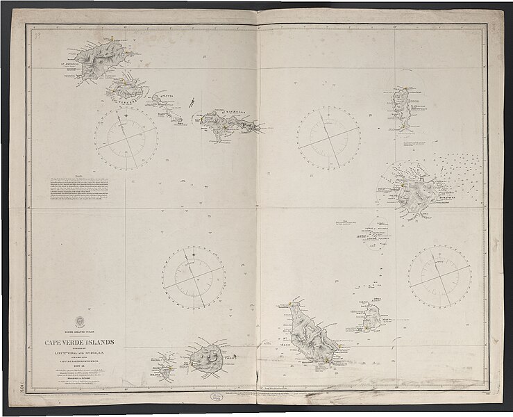
Deutsch: 1 Kt. : unkolor. (75 x 60 cm); Koordinaten W 25°39'00"-W 22°15'00"/N 17°21'00"-N 14°38'00"; Ohne Maßstab. - Titel oben links. - Mit Tiefenangaben. - Korrekturangaben unterhalb des Kt.-Bildes. - Anmerkungen links Mitte. - Relief: Schraffen |
| Date | after 1873 |
| Source | Leibniz-Institut für Länderkunde, Leipzig |
| Author | Vidal, Alexander T. (Hrsg.) |
Karte der Kapverdischen Inseln
Licensing edit
| This file is made available under the Creative Commons CC0 1.0 Universal Public Domain Dedication. | |
| The person who associated a work with this deed has dedicated the work to the public domain by waiving all of their rights to the work worldwide under copyright law, including all related and neighboring rights, to the extent allowed by law. You can copy, modify, distribute and perform the work, even for commercial purposes, all without asking permission.
|
File history
Click on a date/time to view the file as it appeared at that time.
| Date/Time | Thumbnail | Dimensions | User | Comment | |
|---|---|---|---|---|---|
| current | 12:24, 5 September 2018 | | 10,242 × 8,310 (9.19 MB) | Higgenhorscht (talk | contribs) | User created page with UploadWizard |
You cannot overwrite this file.
File usage on Commons
The following page uses this file:
- File:North Atlantic Ocean - Cape Verde Islands.jpg (file redirect)