File:Aerial image of Christchurch suburbs - Flickr - NZ Defence Force (1).jpg

Size of this preview: 800 × 532 pixels. Other resolutions: 320 × 213 pixels | 640 × 426 pixels | 1,024 × 682 pixels | 1,280 × 852 pixels | 1,800 × 1,198 pixels.
Original file (1,800 × 1,198 pixels, file size: 564 KB, MIME type: image/jpeg)
Captions
Captions
Add a one-line explanation of what this file represents
Summary edit
.jpg&action=edit§ion=1)
| Description |
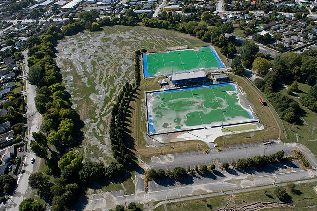
Aerial view of Porritt Park, Christchurch, 5 days after the February 2011 earthquake. Much of the park is covered in mud produced by liquefaction. Flickr caption: "Aerial image of Christchurch suburbs for the Earthquake Commission 20110227_WN_S1015650_0012." |
| Date | |
| Source | Aerial image of Christchurch suburbs |
| Author | New Zealand Defence Force from Wellington, New Zealand |
Licensing edit
.jpg&action=edit§ion=2)
This file is licensed under the Creative Commons Attribution 2.0 Generic license.
- You are free:
- to share – to copy, distribute and transmit the work
- to remix – to adapt the work
- Under the following conditions:
- attribution – You must give appropriate credit, provide a link to the license, and indicate if changes were made. You may do so in any reasonable manner, but not in any way that suggests the licensor endorses you or your use.
| This image was originally posted to Flickr by NZ Defence Force at https://www.flickr.com/photos/56631565@N06/5484301338. It was reviewed on 7 April 2012 by FlickreviewR and was confirmed to be licensed under the terms of the cc-by-2.0. |
File history
Click on a date/time to view the file as it appeared at that time.
| Date/Time | Thumbnail | Dimensions | User | Comment | |
|---|---|---|---|---|---|
| current | 03:44, 7 April 2012 | | 1,800 × 1,198 (564 KB) | タチコマ robot (talk | contribs) | {{Information |Description=Aerial image of Christchurch suburbs for the Earthquake Commission 20110227_WN_S1015650_0012 Follow NZ Defence Force updates on: ++++ [http://twitter.com/#!/nzdefenceforce Twitter] ++++ [http://www.youtube.com/NzDefenceFor... |
You cannot overwrite this file.
File usage on Commons
There are no pages that use this file.
File usage on other wikis
The following other wikis use this file:
- Usage on en.wikipedia.org
- Usage on simple.wikipedia.org
.jpg&oldid=861048015)