File:Aerial photograph of Helsinki, Finland, 2020 May.jpg
![File:Aerial photograph of Helsinki, Finland, 2020 May.jpg](https://upload.wikimedia.org/wikipedia/commons/thumb/1/1c/Aerial_photograph_of_Helsinki%2C_Finland%2C_2020_May.jpg/800px-Aerial_photograph_of_Helsinki%2C_Finland%2C_2020_May.jpg?20230403110748)
Original file (3,840 × 2,560 pixels, file size: 3.48 MB, MIME type: image/jpeg)
Captions
Captions
Summary
editAuthor |
Suomen Ilmakuva OY |
|||||||||||||||||||||||
Description |
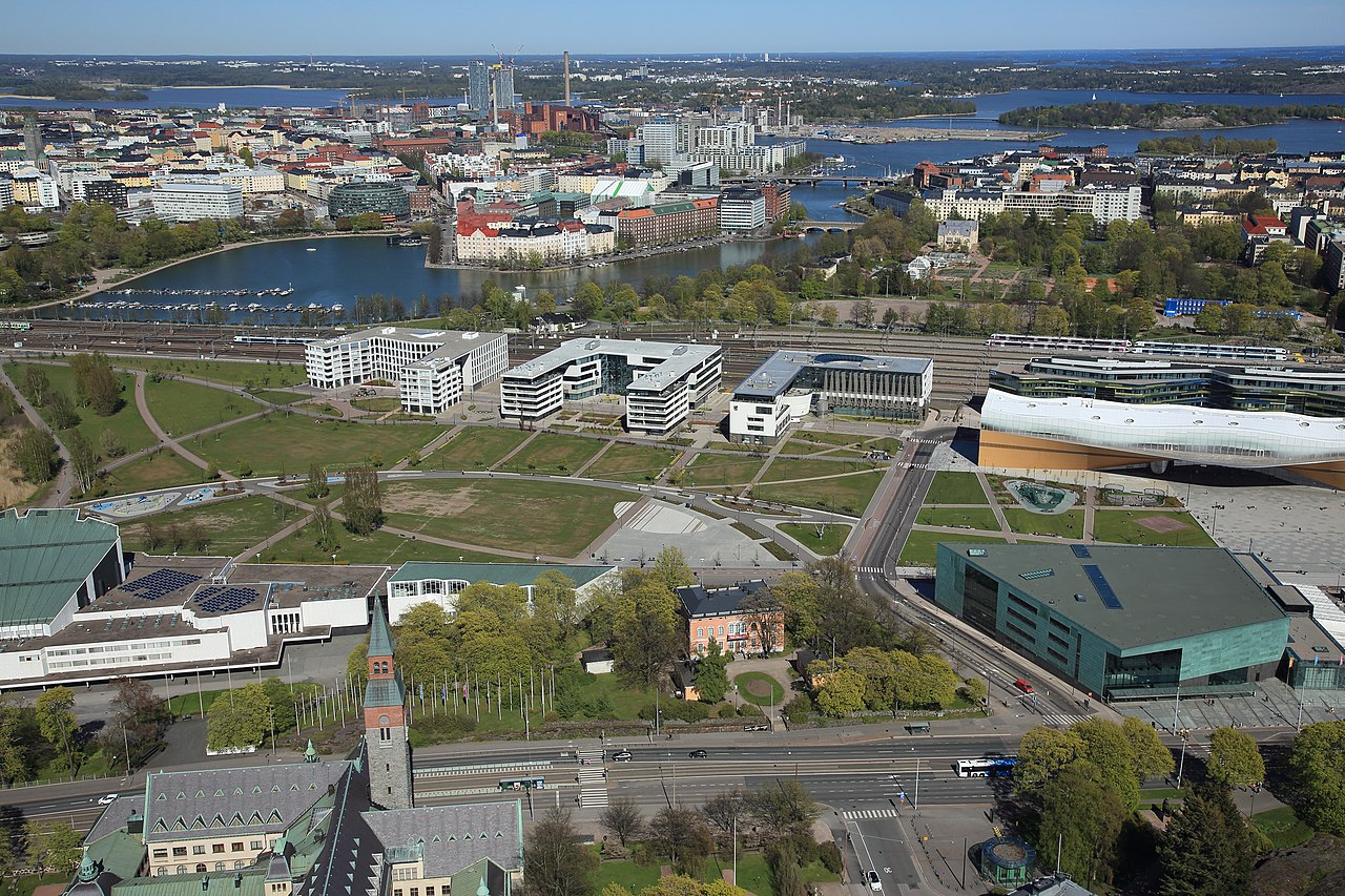
English: Ilmakuva toukokuulta 2020. Näkymä Etu-Töölön yltä itään päin, kohden Kluuvia, Kruununhakaa ja Siltasaarta.
Etualalla vasemmalla Kansallismuseo ja Finlandia-talo, siitä oikealle Hakasalmen huvila sekä Musiikkitalo. Näiden takana avautuu vasemmalla Töölönlahden puisto sekä Makasiinipuisto oikealla. Puistovyöhykkeen takana näkyy Alvar Aallon kadun varrella olevia toimisto- ja asuinrakennuksia sekä oikeassa reunassa Helsingin keskustakirjasto Oodi. Junaradan takana oikealla on Kaisaniemen puisto ja Kruununhaka. Puistossa näkyvät Kansallisteatterin peruskorjauksen aikaiset siniset työmaaparakit. Vasemmalla näkyvät Tokoinranta, Eläintarhanlahti, Kallio ja Siltasaari. Taustalla korkeina rakennuksina erottuvat, muun muassa Merihaan kerrostalot, Hanasaaren B-voimalaitos ja Kalasataman tornitalot. |
|||||||||||||||||||||||
Depicted place |
Suomi: Suomi, Uusimaa, Helsinki, Töölö Helsinki, Etu-Töölö Helsinki, Mannerheimintie 13a, 13b, 13e, 32. Alvar Aallon katu. |
|||||||||||||||||||||||
Date | 22 May 2020, 16:13:30 | |||||||||||||||||||||||
Collection |
institution QS:P195,Q2031357 |
|||||||||||||||||||||||
Accession number |
G70038 |
|||||||||||||||||||||||
Source | https://finna.fi/Record/hkm.FE452477-FBCD-4DF7-87A8-05F4C54FA5C0?sid=2917364644 |
Camera location | 60° 10′ 25.44″ N, 24° 55′ 41.75″ E ![]() ![]() | View this and other nearby images on: OpenStreetMap | ![]() |
---|
Licensing
edit![w:en:Creative Commons](https://upload.wikimedia.org/wikipedia/commons/thumb/7/79/CC_some_rights_reserved.svg/90px-CC_some_rights_reserved.svg.png)
![attribution](https://upload.wikimedia.org/wikipedia/commons/thumb/1/11/Cc-by_new_white.svg/24px-Cc-by_new_white.svg.png)
- You are free:
- to share – to copy, distribute and transmit the work
- to remix – to adapt the work
- Under the following conditions:
- attribution – You must give appropriate credit, provide a link to the license, and indicate if changes were made. You may do so in any reasonable manner, but not in any way that suggests the licensor endorses you or your use.
Annotations InfoField | This image is annotated: View the annotations at Commons |
File history
Click on a date/time to view the file as it appeared at that time.
Date/Time | Thumbnail | Dimensions | User | Comment | |
---|---|---|---|---|---|
current | 11:07, 3 April 2023 | ![]() | 3,840 × 2,560 (3.48 MB) | Coen (talk | contribs) | Uploaded a work by Svuomen Ilmakuva OY from https://finna.fi/Record/hkm.FE452477-FBCD-4DF7-87A8-05F4C54FA5C0?sid=2917364644 with UploadWizard |
You cannot overwrite this file.
File usage on Commons
The following 2 pages use this file:
File usage on other wikis
The following other wikis use this file:
- Usage on fi.wikipedia.org
- Usage on fr.wikipedia.org
Metadata
This file contains additional information such as Exif metadata which may have been added by the digital camera, scanner, or software program used to create or digitize it. If the file has been modified from its original state, some details such as the timestamp may not fully reflect those of the original file. The timestamp is only as accurate as the clock in the camera, and it may be completely wrong.
Camera manufacturer | Canon |
---|---|
Camera model | Canon EOS 5D Mark III |
Exposure time | 1/1,000 sec (0.001) |
F-number | f/10 |
ISO speed rating | 320 |
Date and time of data generation | 16:13, 22 May 2020 |
Lens focal length | 35 mm |
Latitude | 60° 10′ 25.43″ N |
Longitude | 24° 55′ 41.75″ E |
Altitude | 160.2 meters above sea level |
Width | 3,840 px |
Height | 2,560 px |
Bits per component |
|
Compression scheme | Uncompressed |
Pixel composition | RGB |
Orientation | Normal |
Number of components | 3 |
Horizontal resolution | 72 dpi |
Vertical resolution | 72 dpi |
Data arrangement | chunky format |
Software used | Adobe Photoshop CC 2019 (Windows) |
File change date and time | 09:34, 15 February 2021 |
Exposure Program | Shutter priority |
Exif version | 2.3 |
Date and time of digitizing | 16:13, 22 May 2020 |
Meaning of each component |
|
APEX shutter speed | 10 |
APEX aperture | 6.625 |
APEX exposure bias | −0.33333333333333 |
Metering mode | Pattern |
Flash | Flash did not fire |
DateTime subseconds | 00 |
DateTimeOriginal subseconds | 00 |
DateTimeDigitized subseconds | 00 |
Supported Flashpix version | 1 |
Color space | sRGB |
Custom image processing | Normal process |
Exposure mode | Auto exposure |
White balance | Manual white balance |
Scene capture type | Standard |
GPS time (atomic clock) | 13:13:30.493 |
Satellites used for measurement | 12 |
Receiver status | Measurement in progress |
Measurement mode | 3-dimensional measurement |
Measurement precision | Poor (5.9) |
Speed unit | |
Speed of GPS receiver | 0 |
Reference for direction of movement | |
Direction of movement | 0 |
Reference for direction of image | Magnetic direction |
Direction of image | 57 |
Geodetic survey data used | WGS-84 |
Reference for bearing of destination | |
Bearing of destination | 0 |
Reference for distance to destination | |
Distance to destination | 0 |
GPS date | 22 May 2020 |
GPS differential correction | 0 |
GPS tag version | 0.0.3.2 |
Rating (out of 5) | 0 |
Date metadata was last modified | 11:34, 15 February 2021 |
Unique ID of original document | xmp.did:f65f7ee7-2558-6648-823a-564a0d8c996d |