File:Aerial view, Krishna river, India October 2012.jpg
No higher resolution available.
Aerial_view,_Krishna_river,_India_October_2012.jpg (720 × 480 pixels, file size: 73 KB, MIME type: image/jpeg)
Captions
Captions
Add a one-line explanation of what this file represents
Summary edit
| Description |
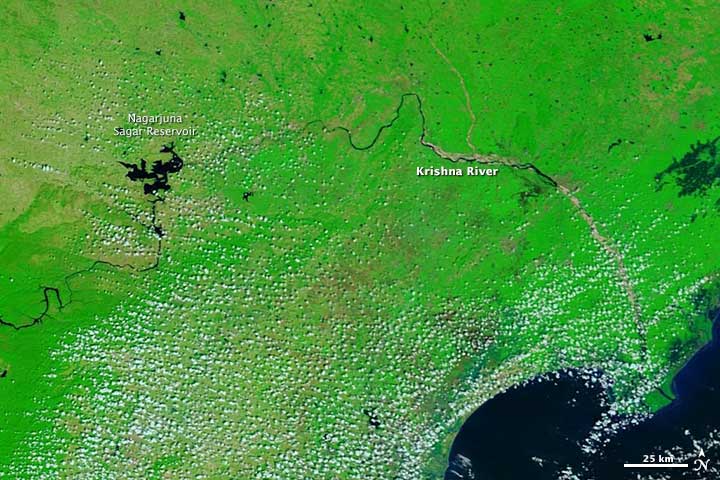
English: The image, taken by Terra MODIS on October 27, 2012, shows normal conditions for River Krishna at this time of year.
The images combine visible and infrared light so that water is black and dark blue, clouds are light blue and white, and plant-covered land is bright green. The Nagarjuna Sagar Reservoir visible in the image is part of a hydroelectric power and irrigation project credited with Green Revolution in India; it also is one of the earliest multi-purpose irrigation and hydro-electric projects in India. The Krishna River is the third longest river in India after the Ganges and the Godavari. It starts in Western Ghats, flows through Karnataka and Andhra Pradesh. |
| Date | |
| Source | http://earthobservatory.nasa.gov/NaturalHazards/view.php?id=82253 |
| Author | NASA |
Licensing edit
| This file is in the public domain in the United States because it was solely created by NASA. NASA copyright policy states that "NASA material is not protected by copyright unless noted". (See Template:PD-USGov, NASA copyright policy page or JPL Image Use Policy.) | ||
 |
Warnings:
|
File history
Click on a date/time to view the file as it appeared at that time.
| Date/Time | Thumbnail | Dimensions | User | Comment | |
|---|---|---|---|---|---|
| current | 22:25, 16 December 2013 | | 720 × 480 (73 KB) | M Tracy Hunter (talk | contribs) | User created page with UploadWizard |
You cannot overwrite this file.
File usage on Commons
There are no pages that use this file.
File usage on other wikis
The following other wikis use this file:
- Usage on ca.wikipedia.org