File:Akers Runo.jpg

Original file (579 × 921 pixels, file size: 252 KB, MIME type: image/jpeg)
Captions
Captions
Summary edit
| Description |
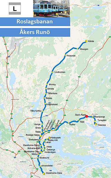
English: Map of Roslagsbanan station Åkers Runö |
|||
| Date | ||||
| Source | Own work based on Light rail logo.jpg, Roslagsbanan Stockholms Östra 2014z.jpg and OpenStreetMap content | |||
| Author |
|
|||
| Permission (Reusing this file) |
The photograph Roslagsbanan Stockholms Östra 2014z.jpg by Holger.Ellgaard, used in this work, is available under the Creative Commons Attribution-ShareAlike 3.0 license (CC-BY-SA 3.0). OpenStreetMap data is available under the Open Database License (details). Map tiles are licensed under the Creative Commons Attribution-ShareAlike 2.0 license (CC-BY-SA 2.0).
|
Licensing edit
- You are free:
- to share – to copy, distribute and transmit the work
- to remix – to adapt the work
- Under the following conditions:
- attribution – You must give appropriate credit, provide a link to the license, and indicate if changes were made. You may do so in any reasonable manner, but not in any way that suggests the licensor endorses you or your use.
- share alike – If you remix, transform, or build upon the material, you must distribute your contributions under the same or compatible license as the original.
File history
Click on a date/time to view the file as it appeared at that time.
| Date/Time | Thumbnail | Dimensions | User | Comment | |
|---|---|---|---|---|---|
| current | 13:47, 28 June 2014 | | 579 × 921 (252 KB) | Tomiwoj (talk | contribs) | Logo changed to "L" - loklbanor/light rail,based on image/info from http://sl.se/ficktid/karta%2Fvinter/SL_Sp%E5rtrafik_2012.pdf |
| 17:09, 25 May 2014 |  | 579 × 921 (260 KB) | Tomiwoj (talk | contribs) | New image using the OpenStreetMap source. |
You cannot overwrite this file.
File usage on Commons
There are no pages that use this file.
File usage on other wikis
The following other wikis use this file:
- Usage on sv.wikipedia.org