File:Akhtala fortress3.jpg

Size of this preview: 800 × 531 pixels. Other resolutions: 320 × 213 pixels | 640 × 425 pixels | 1,024 × 680 pixels | 1,280 × 850 pixels | 2,560 × 1,700 pixels | 3,216 × 2,136 pixels.
Original file (3,216 × 2,136 pixels, file size: 1.74 MB, MIME type: image/jpeg)
Captions
Captions
Add a one-line explanation of what this file represents
Summary edit
| Description |
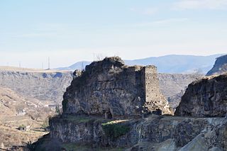
Հայերեն: Ամրոց 13-րդ դ. գտնվում է Ախթալա կայարանի հս մասում, Դեբեդ և Ախթալա ձորերի միացման անկյունում՝ ժայռոտ բլրի գագաթին: Ավերված է: English: Fortress 13c., located at the junction of gorges of Debed Akhtala rivers, on top of a rocky hill. Destroyed. Русский: Крепость 13в., находится на месте слияния ущелий рек Дебед и Акхтала на вершине скалистого утеса. Разрушена.
|
||
| Date | |||
| Source | Own work | ||
| Author | Armen Manukov |
| Camera location | | View this and other nearby images on: OpenStreetMap |
|---|
Licensing edit
I, the copyright holder of this work, hereby publish it under the following license:
This file is licensed under the Creative Commons Attribution-Share Alike 3.0 Unported license.
- You are free:
- to share – to copy, distribute and transmit the work
- to remix – to adapt the work
- Under the following conditions:
- attribution – You must give appropriate credit, provide a link to the license, and indicate if changes were made. You may do so in any reasonable manner, but not in any way that suggests the licensor endorses you or your use.
- share alike – If you remix, transform, or build upon the material, you must distribute your contributions under the same or compatible license as the original.

|
This image was uploaded as part of Wiki Loves Monuments 2013.
|
 |
File history
Click on a date/time to view the file as it appeared at that time.
| Date/Time | Thumbnail | Dimensions | User | Comment | |
|---|---|---|---|---|---|
| current | 10:05, 22 September 2013 | | 3,216 × 2,136 (1.74 MB) | Armen Manukov (talk | contribs) | User created page with UploadWizard |
You cannot overwrite this file.
File usage on Commons
The following page uses this file:
File usage on other wikis
The following other wikis use this file:
- Usage on hy.wikipedia.org