File:AkronCitySeriesMembers.png
Size of this preview: 606 × 599 pixels. Other resolutions: 243 × 240 pixels | 486 × 480 pixels | 781 × 772 pixels.
Original file (781 × 772 pixels, file size: 22 KB, MIME type: image/png)
Captions
Captions
Add a one-line explanation of what this file represents
Summary edit
| Description |
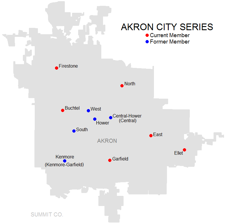
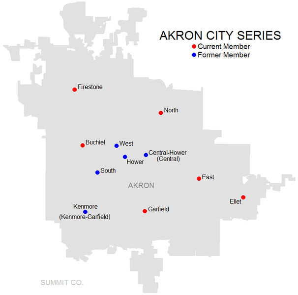
English: Map showing the Akron City Series members (Central's and Hower's individual locations not shown due to spacing, may be changed later on) |
| Source | http://www2.census.gov/geo/maps/general_ref/stco_outline/cen2k_pgsz/stco_OH.pdf |
| Author | Frank12 |
Licensing edit
This image or file is a work of a United States Census Bureau employee, taken or made as part of that person's official duties. As a work of the U.S. federal government, the image is in the public domain.
|
 |
Original upload log edit
The original description page was here. All following user names refer to en.wikipedia.
| Date/Time | Dimensions | User | Comment |
|---|---|---|---|
| 2012-01-27 00:57 | 537×553× (17729 bytes) | Frank12 | Updated to show Hower's location. |
| 2012-01-26 03:49 | 537×553× (16587 bytes) | Frank12 | {{Information |Description = Map showing the Akron City Series members (Central's and Hower's individual locations not shown due to spacing, may be changed later on) |Source = http://www2.census.gov/geo/maps/general_ref/stco_outline/cen2k_pgs |
File history
Click on a date/time to view the file as it appeared at that time.
| Date/Time | Thumbnail | Dimensions | User | Comment | |
|---|---|---|---|---|---|
| current | 18:12, 25 May 2022 | | 781 × 772 (22 KB) | 14Frank12 (talk | contribs) | Updated map to show Kenmore-Garfield as a former member and Garfield as a current member |
| 03:40, 2 June 2021 |  | 781 × 772 (23 KB) | Frank12 (talk | contribs) | Reverted to version as of 20:16, 19 June 2018 (UTC) after researching, I determined that Kenmore-Garfield is still at the Kenmore location. In 2022, the map will change to show the new Garfield CLC at the previous Garfield location. | |
| 03:10, 2 June 2021 |  | 781 × 772 (23 KB) | Frank12 (talk | contribs) | showing correct map now | |
| 03:09, 2 June 2021 |  | 894 × 553 (15 KB) | Frank12 (talk | contribs) | shows the K-G location moved to where Garfield was | |
| 20:16, 19 June 2018 |  | 781 × 772 (23 KB) | Frank12 (talk | contribs) | Added a table to designate current and former members, labeled the city, and cleaned it up by eliminating the neighboring counties. | |
| 20:10, 19 June 2018 |  | 813 × 838 (18 KB) | Frank12 (talk | contribs) | Zoomed in on the school locations more to show them within the city limits. | |
| 16:36, 29 May 2016 |  | 537 × 553 (17 KB) | OgreBot (talk | contribs) | (BOT): Reverting to most recent version before archival | |
| 16:35, 29 May 2016 |  | 537 × 553 (16 KB) | OgreBot (talk | contribs) | (BOT): Uploading old version of file from en.wikipedia; originally uploaded on 2012-01-26 03:49:13 by Frank12 | |
| 04:36, 25 April 2016 |  | 537 × 553 (17 KB) | FastilyClone (talk | contribs) | Transferred from enwp |
You cannot overwrite this file.
File usage on Commons
The following 2 pages use this file:
File usage on other wikis
The following other wikis use this file:
- Usage on en.wikipedia.org
- Firestone Community Learning Center
- Buchtel Community Learning Center
- Kenmore High School
- Garfield High School (Akron, Ohio)
- East Community Learning Center
- North High School (Akron, Ohio)
- National Inventors Hall of Fame STEM High School
- South High School (Akron, Ohio)
- West High School (Akron, Ohio)
- Akron City Series
- Garfield Community Learning Center
- Ellet Community Learning Center
- Template:Akron City Series navbox
- Usage on www.wikidata.org