File:Albania 1965 Spruner Map of the Caucasus and Iraq in Antiquity - Geographicus - CaucusesIraq-spruner-1865.jpg
Size of this preview: 733 × 599 pixels. Other resolutions: 294 × 240 pixels | 587 × 480 pixels | 940 × 768 pixels | 1,085 × 887 pixels.
Original file (1,085 × 887 pixels, file size: 292 KB, MIME type: image/jpeg)
Captions
Captions
Add a one-line explanation of what this file represents
Summary edit
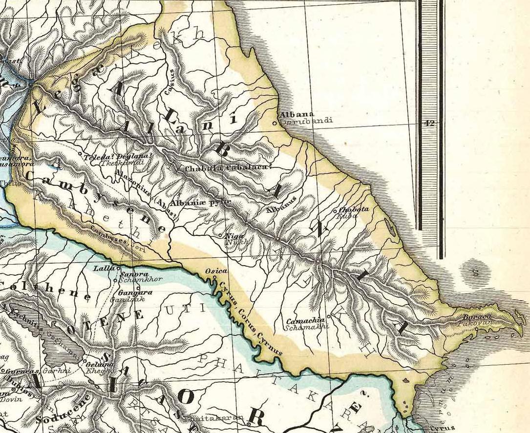
| Karl Spruner von Merz: Albania, Iberia, Colchis, Armenia, Mesopotamia, Babylonia, Assyria.
( |
||||||||||||||||||||
|---|---|---|---|---|---|---|---|---|---|---|---|---|---|---|---|---|---|---|---|---|
| Artist |
|
|||||||||||||||||||
| Title |
Albania, Iberia, Colchis, Armenia, Mesopotamia, Babylonia, Assyria. |
|||||||||||||||||||
| Description |
English: Albania on a particularly interesting map, this is Karl von Spruner’s 1865 rendering of the Caucasus and Mesopotamia in antiquity. Centered on Lake Van (modern day eastern Turkey), this map covers the Caucasus region between the Black Sea and the Caspian Sea, then southwards to the Fertile Crescent as far as the Euphrates River, Babylonia, and the head of the Persian Gulf. These regions include the modern day countries of Iraq, Armenia, Georgia, Azerbaijan, and adjacent parts of Syria, Turkey, Iran, and the North Caucasus. Like most of Spruner’s work this example overlays ancient political geographies on relatively contemporary physical geographies, thus identifying the sites of forgotten towns and villages, the movements of armies, and the disposition of lands in the region. This particular example includes ancient names for many notable regions and historical sites. As a whole the map labels important cities, rivers, mountain ranges and other minor topographical detail. Territories and countries outlined in color. The whole is rendered in finely engraved detail exhibiting the fine craftsmanship for which the Perthes firm is known. Deutsch: Antikes Vorderasien. Die Karte reicht im Westen bis Bosra, Damaskus, Antiochien und die Mündung des Iris (Yeşilırmak) ins Schwarze Meer, im Norden bis Pityus (Pizunda) an der Schwarzmeerküste und zum dagestanischen Fluß Sulak, im Osten bis Abşeron, Ekbatana und Susa und im Süden bis zur Mündung von Euphrat und Tigris. |
|||||||||||||||||||
| Date | 1865 (undated) | |||||||||||||||||||
| Dimensions | height: 16 in (40.6 cm); width: 13 in (33 cm) | |||||||||||||||||||
| Accession number |
Geographicus link: CaucusesIraq-spruner-1865 |
|||||||||||||||||||
| Source/Photographer |
Spruner, Karl von, Spruner-Menke Atlas Antiquus,, (Gotha: Justus Perthes), 1865.
|
|||||||||||||||||||
| Permission (Reusing this file) |
|
|||||||||||||||||||
Licensing edit
|
This is a faithful photographic reproduction of a two-dimensional, public domain work of art. The work of art itself is in the public domain for the following reason:
The official position taken by the Wikimedia Foundation is that "faithful reproductions of two-dimensional public domain works of art are public domain".
This photographic reproduction is therefore also considered to be in the public domain in the United States. In other jurisdictions, re-use of this content may be restricted; see Reuse of PD-Art photographs for details. | ||||
File history
Click on a date/time to view the file as it appeared at that time.
| Date/Time | Thumbnail | Dimensions | User | Comment | |
|---|---|---|---|---|---|
| current | 14:44, 14 February 2012 | | 1,085 × 887 (292 KB) | Interfase (talk | contribs) | == {{int:filedesc}} == {{Artwork |artist = {{Creator:Karl Spruner von Merz}} |title = Albania, Iberia, Colchis, Armenia, Mesopotamia, Babylonia, Assyria. |description = {{en|Albania on a particularly interesting map, this is K |
You cannot overwrite this file.
File usage on Commons
The following page uses this file:
File usage on other wikis
The following other wikis use this file: