File:Alberto 2006-06-11 1620Z.jpg

Original file (7,000 × 9,100 pixels, file size: 34.17 MB, MIME type: image/jpeg)
Captions
Captions
| Warning | The original file is very high-resolution. It might not load properly or could cause your browser to freeze when opened at full size. |
|---|
Summary edit
| Description |
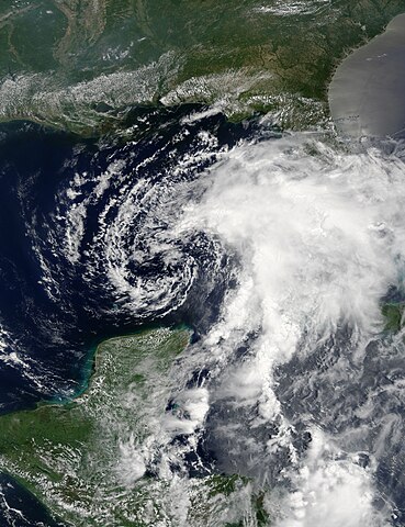
Tropical Storm Alberto formed as a tropical depression early in the morning on June 10, 2006, in the Yucatan Channel. This narrow gap of ocean lies between the western end of Cuba and the Yucatan Peninsula at the mouth of the Gulf of Mexico. Alberto gradually gathered strength as it took a slow track northward into the Gulf. By early morning on June 11, wind strength within the storm crossed the critical threshold of 39 knots (70 kilometers per hour; 45 miles per hour), the minimum wind speed necessary to become classified as a tropical storm and hence earn a name. Thus Alberto became the first named storm of the 2006 Atlantic hurricane season. This photo-like image was acquired by the Moderate Resolution Imaging Spectroradiometer (MODIS) on the Terra satellite on June 11 2006, at 12:20 p.m. local time (16:20 UTC). The tropical storm did have a wispy spiral structure, centered north of the Yucatan Peninsula in this satellite image, but there was little other evidence of a well-developed storm. To the east of the storm center, a large bank of clouds sprawled over the eastern Gulf of Mexico and southern Florida. Sustained winds in the storm system were estimated to be around 70 kilometers per hour (45 miles per hour) around the time the image was captured, according to the University of Hawaii’s Tropical Storm Information Center. However, the less-than-hurricane-strength winds did not mean that Alberto posed no significant hazards. Rainfall totals from the storm were predicted to be between 12 to 25 centimeters (5 to 10 inches), and the storm center was also expected to spawn tornadoes once Alberto crossed land. Drought-stricken Florida was looking for rain, but the heavy downpours predicted were also causing concerns about local flooding. |
|||||
| Date | ||||||
| Source | http://earthobservatory.nasa.gov/NaturalHazards/natural_hazards_v2.php3?img_id=13636 | |||||
| Author | NASA image created by Jesse Allen, Earth Observatory, using data obtained courtesy of the MODIS Rapid Response team. | |||||
| Permission (Reusing this file) |
|

File history
Click on a date/time to view the file as it appeared at that time.
| Date/Time | Thumbnail | Dimensions | User | Comment | |
|---|---|---|---|---|---|
| current | 02:28, 6 September 2019 | | 7,000 × 9,100 (34.17 MB) | Supportstorm (talk | contribs) | Higher quality |
| 16:16, 27 December 2015 |  | 7,500 × 7,500 (7.62 MB) | Nino Marakot (talk | contribs) | Reverted to version as of 01:03, 26 September 2006 (UTC) | |
| 18:55, 30 June 2010 |  | 7,500 × 7,500 (7.19 MB) | Supportstorm (talk | contribs) | Contrast Correction, Sharpened Equalized | |
| 01:03, 26 September 2006 |  | 7,500 × 7,500 (7.62 MB) | Good kitty (talk | contribs) | ||
| 14:39, 13 June 2006 |  | 2,500 × 2,500 (857 KB) | Mosesofmason (talk | contribs) | {{Information |Description=Tropical Storm Alberto Tropical Storm Alberto formed as a tropical depression early in the morning on June 10, 2006, in the Yucatan Channel. This narrow gap of ocean lies between the western end of Cuba and the Yucatan Peninsul |
You cannot overwrite this file.
File usage on Commons
The following 5 pages use this file:
File usage on other wikis
The following other wikis use this file:
- Usage on zh.wikinews.org