File:Algoma Steel Sault Ste Marie USGS.jpg

Size of this preview: 800 × 494 pixels. Other resolutions: 320 × 198 pixels | 640 × 396 pixels | 1,024 × 633 pixels | 1,254 × 775 pixels.
Original file (1,254 × 775 pixels, file size: 297 KB, MIME type: image/jpeg)
Captions
Captions
Add a one-line explanation of what this file represents
| Description |
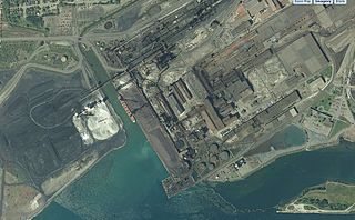
English: View of the Algoma Steel complex as seen in The National Map. A freighter can be seen in the canal near the center of the image. Scale of 1:9,028.
Used GIMP to remove map legend. |
|||
| Date | Unknown date, late 2000's | |||
| Source | USGS National Map, http://viewer.nationalmap.gov/viewer/?p=default&b=base2&x=-9392430.210804494&y=5863847.799763964&l=16&sc=&v= | |||
| Author | USGS | |||
| Permission (Reusing this file) |
|
File history
Click on a date/time to view the file as it appeared at that time.
| Date/Time | Thumbnail | Dimensions | User | Comment | |
|---|---|---|---|---|---|
| current | 00:41, 10 September 2012 | | 1,254 × 775 (297 KB) | Oaktree b (talk | contribs) | {{Information |Description ={{en|1=View of the Algoma Steel complex as seen in The National Map. A freighter can be seen in the canal near the center of the image. Scale of 1:9,028. Used GIMP to remove map legend.}} |Source =USGS National Ma... |
You cannot overwrite this file.
File usage on Commons
The following page uses this file: