File:AlteSalzstrasse.png
No higher resolution available.
AlteSalzstrasse.png (188 × 235 pixels, file size: 7 KB, MIME type: image/png)
Captions
Captions
Add a one-line explanation of what this file represents

|
This locator map image could be re-created using vector graphics as an SVG file. This has several advantages; see Commons:Media for cleanup for more information. If an SVG form of this image is available, please upload it and afterwards replace this template with
{{vector version available|new image name}}.
It is recommended to name the SVG file “AlteSalzstrasse.svg”—then the template Vector version available (or Vva) does not need the new image name parameter. |
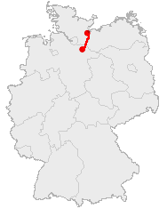
| Description | Course Map of Alte Saltzstraße |
| Date | |
| Source | made by 汲平 based on the data from OpenGeoDB |
| Author | 汲平 |
This image was generated with OpenGeoDB. The information there is placed in the public domain, images generated from OpenGeoDB are derivative works without passing the threshold of creativity, they are therefore also public domain.
| This work is ineligible for copyright and therefore in the public domain because it consists entirely of information that is common property and contains no original authorship. |
File history
Click on a date/time to view the file as it appeared at that time.
| Date/Time | Thumbnail | Dimensions | User | Comment | |
|---|---|---|---|---|---|
| current | 02:05, 16 July 2005 | | 188 × 235 (7 KB) | 汲平 (talk | contribs) | {{Information| |Description = Course Map of Alte Saltzstraße |Date = July 16, 2005 |Author = 汲平 |Source = made by 汲平 based on the data from [http://opengeodb.de/suche/ OpenGeoDB] |Permission = }} {{GFDL-OpenGeoDB} |
You cannot overwrite this file.
File usage on Commons
The following page uses this file:
File usage on other wikis
The following other wikis use this file:
- Usage on ca.wikipedia.org
- Usage on da.wikipedia.org
- Usage on de.wikipedia.org
- Usage on en.wikipedia.org
- Usage on es.wikipedia.org
- Usage on fr.wikipedia.org
- Usage on ja.wikipedia.org
- Usage on ta.wikipedia.org
- Usage on th.wikipedia.org
- Usage on www.wikidata.org