File:Anatolia ca 740 AD-es.svg

Size of this PNG preview of this SVG file: 800 × 415 pixels. Other resolutions: 320 × 166 pixels | 640 × 332 pixels | 1,024 × 531 pixels | 1,280 × 664 pixels | 2,560 × 1,328 pixels | 925 × 480 pixels.
Original file (SVG file, nominally 925 × 480 pixels, file size: 17.51 MB)
Captions
Captions
Add a one-line explanation of what this file represents
Summary edit
| Description |
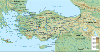
Português: Mapa da Anatólia bizantina em 740 |
| Date | |
| Source | Anatolia ca 740 AD-pt.svg |
| Author |
|
| Other versions |
[]
|


Licensing edit
I, the copyright holder of this work, hereby publish it under the following license:
This file is licensed under the Creative Commons Attribution-Share Alike 4.0 International license.
- You are free:
- to share – to copy, distribute and transmit the work
- to remix – to adapt the work
- Under the following conditions:
- attribution – You must give appropriate credit, provide a link to the license, and indicate if changes were made. You may do so in any reasonable manner, but not in any way that suggests the licensor endorses you or your use.
- share alike – If you remix, transform, or build upon the material, you must distribute your contributions under the same or compatible license as the original.
File history
Click on a date/time to view the file as it appeared at that time.
| Date/Time | Thumbnail | Dimensions | User | Comment | |
|---|---|---|---|---|---|
| current | 00:11, 7 August 2020 | | 925 × 480 (17.51 MB) | Magog the Ogre (talk | contribs) | Reverted to version as of 09:13, 14 August 2019 (UTC) |
| 01:35, 28 August 2019 |  | 925 × 480 (17.51 MB) | Magog the Ogre (talk | contribs) | == {{int:filedesc}} == {{Information |Description={{en|Byzantine Asia Minor (Anatolia) and the Byzantine-Arab frontier region in 740 AD, with provinces, major roads and settlements. Geophysical map taken from from DEMIS Mapserver, which are public domain, other wise self-made. Sources: W. Treadgold, The Byzantine Revival, 780-842 (1988), pp. 12, 336; The Cambridge History of the Byzantine Empire c.500-1492 (2009), p. 371; Droysen - Oströmisches Reich.jpg; A. Kazhdan et al., The Oxford Diction... | |
| 09:13, 14 August 2019 |  | 925 × 480 (17.51 MB) | Rowanwindwhistler (talk | contribs) | New version: Projection:EPSG 2186 Topography & shade: USGS GMTED2010 Rivers, Coast, Sea, land: Natural Earth Location of cities/towns: Wikipedia coordinates (mostly) | |
| 16:04, 30 May 2016 |  | 1,317 × 687 (1.79 MB) | Rowanwindwhistler (talk | contribs) | Abido | |
| 16:17, 4 April 2016 |  | 1,317 × 687 (1.79 MB) | Rowanwindwhistler (talk | contribs) | Legend | |
| 16:14, 4 April 2016 |  | 1,317 × 687 (1.79 MB) | Rowanwindwhistler (talk | contribs) | User created page with UploadWizard |
You cannot overwrite this file.
File usage on Commons
The following 24 pages use this file:
- User:J budissin/Uploads/BiH/2016 April 1-10
- User:J budissin/Uploads/BiH/2016 May 21-31
- User:J budissin/Uploads/BiH/2019 August 11-20
- User:J budissin/Uploads/BiH/2019 August 21-31
- User:Jaqeli/Georgia
- User:Magog the Ogre/Maps of conflicts/2019 August
- User:Magog the Ogre/Multilingual legend/2020 August 1-10
- File:Anatolia ca 740 AD-es.svg
- File:Anatolia ca 740 AD-pt.svg
- File:Asia Minor ca 740 AD-es.svg (file redirect)
- File:Asia Minor ca 740 AD.svg
- File:Anatolia ca 740 AD-pt.svg
- File:Asia Minor ca 780 AD-es.svg
- File:Anatolia ca 740 AD-es.svg
- File:Asia Minor ca 842 AD-es.svg
- File:Asia Minor ca 740 AD ZH.svg
- User:Magog the Ogre/Maps of conflicts/2019 August
- User:J budissin/Uploads/BiH/2019 August 21-31
- Template:Other versions/Asia Minor ca 740 AD
- File:Asia Minor ca 740 AD.svg
- File:Asia Minor ca 740 AD ZH.svg
- File:Asia Minor ca 780 AD-es.svg
- File:Asia Minor ca 842 AD-es.svg
- Template:Other versions/Asia Minor ca 740 AD
File usage on other wikis
The following other wikis use this file:
- Usage on es.wikipedia.org