File:Anderson Manor - geograph.org.uk - 608301.jpg
No higher resolution available.
Anderson_Manor_-_geograph.org.uk_-_608301.jpg (640 × 426 pixels, file size: 197 KB, MIME type: image/jpeg)
Captions
Captions
Add a one-line explanation of what this file represents
Summary edit
| Description |
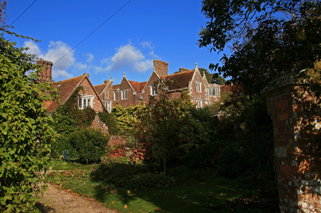
English: Anderson Manor Anderson Manor was built in 1622 for John Tregonwell, and was described three years later in Coker's Survey of Dorsetshire, as a 'faire newe house'. In more recent times it was taken over by the War Dept. during the Second World War, and became the headquarters for the Small Scale Raiding Force of 62 Commando. After the SSRF disbanded in 1943, Anderson Manor ended its wartime role as Station 62 under the Special Operations Executive (S.O.E.). The house is Grade I Listed.
|
|
| Date | ||
| Source | From geograph.org.uk | |
| Author | Mike Searle | |
| Attribution (required by the license) | Mike Searle / Anderson Manor / | |
| Camera location | | View this and other nearby images on: OpenStreetMap |
|---|
_heading:22.00&language=en)
| Object location | | View this and other nearby images on: OpenStreetMap |
|---|
_heading:22.00&language=en)
Licensing edit

|
This image was taken from the Geograph project collection. See this photograph's page on the Geograph website for the photographer's contact details. The copyright on this image is owned by Mike Searle and is licensed for reuse under the Creative Commons Attribution-ShareAlike 2.0 license.
|
This file is licensed under the Creative Commons Attribution-Share Alike 2.0 Generic license.
Attribution: Mike Searle
- You are free:
- to share – to copy, distribute and transmit the work
- to remix – to adapt the work
- Under the following conditions:
- attribution – You must give appropriate credit, provide a link to the license, and indicate if changes were made. You may do so in any reasonable manner, but not in any way that suggests the licensor endorses you or your use.
- share alike – If you remix, transform, or build upon the material, you must distribute your contributions under the same or compatible license as the original.
File history
Click on a date/time to view the file as it appeared at that time.
| Date/Time | Thumbnail | Dimensions | User | Comment | |
|---|---|---|---|---|---|
| current | 22:22, 6 February 2011 | | 640 × 426 (197 KB) | GeographBot (talk | contribs) | == {{int:filedesc}} == {{Information |description={{en|1=Anderson Manor Anderson Manor was built in 1622 for John Tregonwell, and was described three years later in Coker's Survey of Dorsetshire, as a 'faire newe house'. In more recent times it was taken |
You cannot overwrite this file.
File usage on Commons
The following 2 pages use this file:
File usage on other wikis
The following other wikis use this file:
- Usage on ceb.wikipedia.org
- Usage on cy.wikipedia.org
- Usage on dag.wikipedia.org
- Usage on da.wikipedia.org
- Usage on en.wikipedia.org
- Usage on fr.wikipedia.org
- Usage on it.wikipedia.org
- Usage on nl.wikipedia.org
- Usage on pl.wikipedia.org
- Usage on ur.wikipedia.org
- Usage on www.wikidata.org
- Usage on zh-min-nan.wikipedia.org