File:Andora-Catalan border near Os de Civís.png

Size of this preview: 800 × 543 pixels. Other resolutions: 320 × 217 pixels | 640 × 434 pixels | 983 × 667 pixels.
Original file (983 × 667 pixels, file size: 585 KB, MIME type: image/png)
Captions
Captions
Add a one-line explanation of what this file represents
Summary edit
| Description |
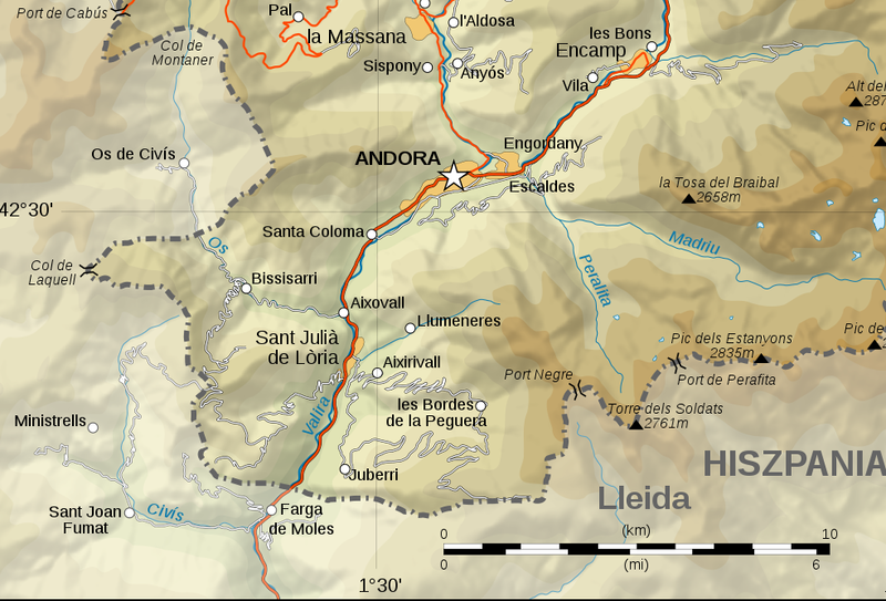
Polski: fragment pogranicza Andory z Katalonią; widoczna tu po stronie hiszpańskiej miejscowość Os de Civís jest praktyczną enklawę (jedyna droga prowadzi do Andory) |
| Date | &2021 |
| Source | own work of Eric Gaba (user:Sting) & user:Grawiton (Polish translation); cropped by user:Julo |
| Author | Eric Gaba (user:Sting) & user:Grawiton |
| Other versions |
 |
Licensing edit
This file is licensed under the Creative Commons Attribution-Share Alike 4.0 International license.
- You are free:
- to share – to copy, distribute and transmit the work
- to remix – to adapt the work
- Under the following conditions:
- attribution – You must give appropriate credit, provide a link to the license, and indicate if changes were made. You may do so in any reasonable manner, but not in any way that suggests the licensor endorses you or your use.
- share alike – If you remix, transform, or build upon the material, you must distribute your contributions under the same or compatible license as the original.
File history
Click on a date/time to view the file as it appeared at that time.
| Date/Time | Thumbnail | Dimensions | User | Comment | |
|---|---|---|---|---|---|
| current | 21:18, 5 December 2021 | | 983 × 667 (585 KB) | Julo (talk | contribs) | png |
You cannot overwrite this file.
File usage on Commons
There are no pages that use this file.
File usage on other wikis
The following other wikis use this file:
- Usage on pl.wikipedia.org