File:Andorra topographic map-it.svg

Size of this PNG preview of this SVG file: 750 × 600 pixels. Other resolutions: 300 × 240 pixels | 600 × 480 pixels | 960 × 768 pixels | 1,280 × 1,024 pixels | 2,560 × 2,048 pixels | 1,625 × 1,300 pixels.
Original file (SVG file, nominally 1,625 × 1,300 pixels, file size: 1.58 MB)
Captions
Captions
Add a one-line explanation of what this file represents
| Description |
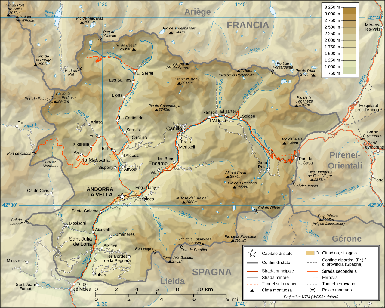
Italiano: Mappa topografica di Andorra, versione in italiano
Deutsch: Topographische Karte von Andorra, italianische Version English: Topographic map in Italian of Andorra Français : Carte topographique en italien de l'Andorre |
| Date | (UTC) |
| Source | |
| Author |
|
| Other versions |
[]
|


| This is a retouched picture, which means that it has been digitally altered from its original version. The original can be viewed here: Andorra topographic map-fr.svg:
|
I, the copyright holder of this work, hereby publish it under the following licenses:
This file is licensed under the Creative Commons Attribution-Share Alike 3.0 Unported, 2.5 Generic, 2.0 Generic and 1.0 Generic license.
- You are free:
- to share – to copy, distribute and transmit the work
- to remix – to adapt the work
- Under the following conditions:
- attribution – You must give appropriate credit, provide a link to the license, and indicate if changes were made. You may do so in any reasonable manner, but not in any way that suggests the licensor endorses you or your use.
- share alike – If you remix, transform, or build upon the material, you must distribute your contributions under the same or compatible license as the original.

|
Permission is granted to copy, distribute and/or modify this document under the terms of the GNU Free Documentation License, Version 1.2 or any later version published by the Free Software Foundation; with no Invariant Sections, no Front-Cover Texts, and no Back-Cover Texts. A copy of the license is included in the section entitled GNU Free Documentation License. |
You may select the license of your choice.
Original upload log edit
This image is a derivative work of the following images:
- Image:Andorra_topographic_map-fr.svg licensed with Cc-by-sa-3.0,2.5,2.0,1.0, GFDL
- 2008-06-12T20:03:47Z Sting 1625x1300 (1654623 Bytes) Correction on a name.
- 2008-03-07T14:37:41Z Sting 1625x1300 (1654334 Bytes) Improved shaded relief and other details
- 2008-02-28T04:26:38Z Sting 1625x1300 (1275242 Bytes) {{Location|42|33|00|N|01|36|00|E|scale:200000}} {{Information |Description={{en|Topographic map in French of [[:Category:Andorra|Andorra]]}}{{fr|Carte topographique en français de l'[[:Category:Andorra|Andorre]]}} |Source={
Uploaded with derivativeFX
File history
Click on a date/time to view the file as it appeared at that time.
| Date/Time | Thumbnail | Dimensions | User | Comment | |
|---|---|---|---|---|---|
| current | 09:19, 8 July 2008 | | 1,625 × 1,300 (1.58 MB) | Kanchelskis (talk | contribs) | {{Information |Description={{it|Mappa topografica di Andorra, versione in italiano}} {{de|Topographische Karte von Andorra, italianische Version}}{{en|Topographic map in Italian of Andorra}}{{fr|Carte topogr |
You cannot overwrite this file.
File usage on Commons
The following 11 pages use this file:
- File:Andorra topographic map-ca.svg
- File:Andorra topographic map-de.svg
- File:Andorra topographic map-en.svg
- File:Andorra topographic map-fr.svg
- File:Andorra topographic map-hu.svg
- File:Andorra topographic map-it.svg
- File:Andorra topographic map-mk.svg
- File:Andorra topographic map-pl.svg
- File:Andorra topographic map-ptbr.svg
- File:Andorra topographic map-sr.svg
- Template:Other versions/Andorra topographic map
File usage on other wikis
The following other wikis use this file:
- Usage on co.wikipedia.org
- Usage on it.wikipedia.org
- Usage on nap.wikipedia.org
- Usage on roa-tara.wikipedia.org
- Usage on www.wikidata.org