File:Angerberg 1774.jpg

Size of this preview: 497 × 600 pixels. Other resolutions: 199 × 240 pixels | 398 × 480 pixels | 768 × 927 pixels.
Original file (768 × 927 pixels, file size: 355 KB, MIME type: image/jpeg)
Captions
Captions
Add a one-line explanation of what this file represents
| Description |
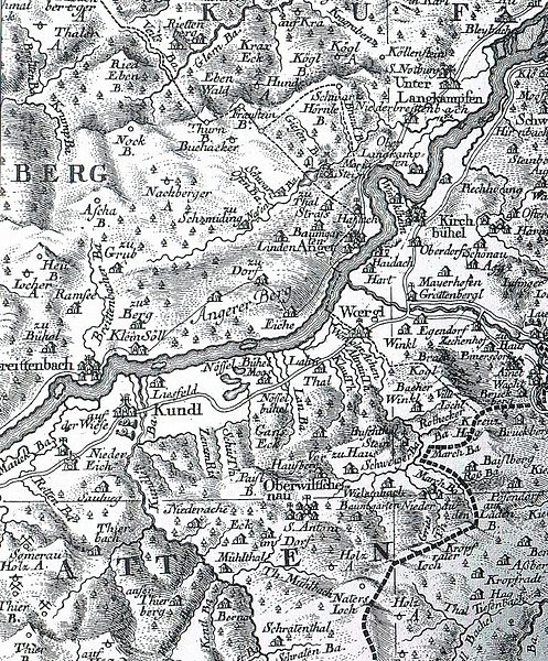
English: Map of Tyrol by Blasius Hueber (1735-1814) and Peter Anich (1726-1766).
Deutsch: Landkarte Tirols von Blasius Hueber (1735-1814) and Peter Anich (1726-1766). |
| Date | |
| Source | Angerberger Dorfbüchl |
| Author | eigene Arbeit |
|
This work is in the public domain in its country of origin and other countries and areas where the copyright term is the author's life plus 100 years or fewer. | |
| This file has been identified as being free of known restrictions under copyright law, including all related and neighboring rights. | |
File history
Click on a date/time to view the file as it appeared at that time.
| Date/Time | Thumbnail | Dimensions | User | Comment | |
|---|---|---|---|---|---|
| current | 13:49, 7 May 2010 | | 768 × 927 (355 KB) | A18 (talk | contribs) | {{Information |Description={{en|1=Map of Tyrol by Blasius Hueber (1735-1814) and Peter Anich (1726-1766).}} {{de|1=Landkarte Tirols von Blasius Hueber (1735-1814) and Peter Anich (1726-1766).}} |Source=Angerberger Dorfbüchl |Author=eigene Arbeit |Date=17 |
You cannot overwrite this file.
File usage on Commons
There are no pages that use this file.
File usage on other wikis
The following other wikis use this file:
- Usage on de.wikipedia.org