File:Annait - geograph.org.uk - 115832.jpg
Annait_-_geograph.org.uk_-_115832.jpg (640 × 480 pixels, file size: 133 KB, MIME type: image/jpeg)
Captions
Captions
Summary edit
| DescriptionAnnait - geograph.org.uk - 115832.jpg |
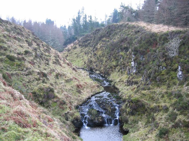
English: Annait. Interesting place, Annait. It is marked 'Annait' on the OS map but I have seen it spelt 'anait' elsewhere. Possibly it should be 'the Annait' or 'an anait', I'm not sure.
It is also difficult to give a decent impression of what it looks like in a photograph. You need to stand on it and look all around to really appreciate it. It is a pointed piece of ground between two small rivers, immediately above their confluence. Each of the rivers flows in a gorge. The photograph here shows the gorge on the left as you look downstream. A quite excellent defensive position. It is not that easy to reach even when nobody is defending it! There are signs of ruined walls on the top, including one heavy wall that would have once barred access to the point other than by a single entranceway. What was its purpose? How old is it? Who knows? I have come across some contradictory theories. The one I tend to believe is that Annat sites, of which there are several in the north west of Scotland, appear to be pre-Christian and apparently relate to the worship of Anaitis, the Mother Goddess of the ancient East. In the old Hebrew-Phoenician pantheon, Anaitis or Anath was the sister of the sun god Baal or Bel who was also worshipped in Scotland and Ireland, by the lighting of Beltane fires. Anaitis, from whence, in all probability, is derived the gaelic term annat, was a pre-Christian female deity or goddess who was worshipped not only in Egypt but also in Palestine and Asia Minor. Alexander Forbes (Place-Names of Skye -1923) comments: "Many of the Annats are claimedand it is believed correctlyas pre-Christian. |
| Date | |
| Source | From geograph.org.uk |
| Author | John Allan |
| Attribution (required by the license) InfoField | John Allan / Annait / |
InfoField | John Allan / Annait |
| Object location | 57° 29′ 04″ N, 6° 33′ 11″ W | View this and other nearby images on: OpenStreetMap |
|---|
Licensing edit

|
This image was taken from the Geograph project collection. See this photograph's page on the Geograph website for the photographer's contact details. The copyright on this image is owned by John Allan and is licensed for reuse under the Creative Commons Attribution-ShareAlike 2.0 license.
|
- You are free:
- to share – to copy, distribute and transmit the work
- to remix – to adapt the work
- Under the following conditions:
- attribution – You must give appropriate credit, provide a link to the license, and indicate if changes were made. You may do so in any reasonable manner, but not in any way that suggests the licensor endorses you or your use.
- share alike – If you remix, transform, or build upon the material, you must distribute your contributions under the same or compatible license as the original.
File history
Click on a date/time to view the file as it appeared at that time.
| Date/Time | Thumbnail | Dimensions | User | Comment | |
|---|---|---|---|---|---|
| current | 00:16, 31 January 2010 |  | 640 × 480 (133 KB) | GeographBot (talk | contribs) | == {{int:filedesc}} == {{Information |description={{en|1=Annait. Interesting place, Annait. It is marked 'Annait' on the OS map but I have seen it spelt 'anait' elsewhere. Possibly it should be 'the Annait' or 'an anait', I'm not sure. It is also difficu |
You cannot overwrite this file.
File usage on Commons
There are no pages that use this file.
Metadata
This file contains additional information such as Exif metadata which may have been added by the digital camera, scanner, or software program used to create or digitize it. If the file has been modified from its original state, some details such as the timestamp may not fully reflect those of the original file. The timestamp is only as accurate as the clock in the camera, and it may be completely wrong.
| Camera manufacturer | Canon |
|---|---|
| Camera model | Canon DIGITAL IXUS 400 |
| Exposure time | 1/60 sec (0.016666666666667) |
| F-number | f/2.8 |
| Date and time of data generation | 11:40, 1 February 2006 |
| Lens focal length | 7.40625 mm |
| Orientation | Normal |
| Horizontal resolution | 180 dpi |
| Vertical resolution | 180 dpi |
| File change date and time | 11:40, 1 February 2006 |
| Y and C positioning | Centered |
| Exif version | 2.2 |
| Date and time of digitizing | 11:40, 1 February 2006 |
| Image compression mode | 5 |
| APEX shutter speed | 5.90625 |
| APEX aperture | 2.96875 |
| APEX exposure bias | 0 |
| Maximum land aperture | 2.96875 APEX (f/2.8) |
| Metering mode | Pattern |
| Flash | Flash did not fire, auto mode |
| Color space | sRGB |
| Focal plane X resolution | 8,114.2857142857 |
| Focal plane Y resolution | 8,114.2857142857 |
| Focal plane resolution unit | inches |
| Sensing method | One-chip color area sensor |
| Custom image processing | Normal process |
| Exposure mode | Auto exposure |
| White balance | Auto white balance |
| Digital zoom ratio | 1 |
| Scene capture type | Standard |
