File:Antarctica Farthest Souths.svg

Size of this PNG preview of this SVG file: 532 × 599 pixels. Other resolutions: 213 × 240 pixels | 426 × 480 pixels | 682 × 768 pixels | 909 × 1,024 pixels | 1,818 × 2,048 pixels | 1,144 × 1,289 pixels.
Original file (SVG file, nominally 1,144 × 1,289 pixels, file size: 63 KB)
Captions
Captions
Add a one-line explanation of what this file represents
Summary edit
| Description |
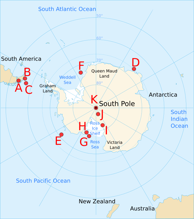
English: Map of Antarctica and the southern hemisphere for the w:Farthest South article, showing farthest south records from 1521 to 1911, as follows:
|
| Date | |
| Source | Based on Image:Antarctica blank.svg, Image:Antarctica Map.png, and Image:Farthest South map.png |
| Author | Jappalang |
| Other versions |
Image:Farthest South map.png — based on this PNG version
|


This W3C-unspecified vector image was created with Inkscape .
Licensing edit
I, the copyright holder of this work, hereby publish it under the following licenses:
This file is licensed under the Creative Commons Attribution-Share Alike 3.0 Unported license.
- You are free:
- to share – to copy, distribute and transmit the work
- to remix – to adapt the work
- Under the following conditions:
- attribution – You must give appropriate credit, provide a link to the license, and indicate if changes were made. You may do so in any reasonable manner, but not in any way that suggests the licensor endorses you or your use.
- share alike – If you remix, transform, or build upon the material, you must distribute your contributions under the same or compatible license as the original.

|
Permission is granted to copy, distribute and/or modify this document under the terms of the GNU Free Documentation License, Version 1.2 or any later version published by the Free Software Foundation; with no Invariant Sections, no Front-Cover Texts, and no Back-Cover Texts. A copy of the license is included in the section entitled GNU Free Documentation License. |
You may select the license of your choice.
File history
Click on a date/time to view the file as it appeared at that time.
| Date/Time | Thumbnail | Dimensions | User | Comment | |
|---|---|---|---|---|---|
| current | 12:01, 2 October 2008 | | 1,144 × 1,289 (63 KB) | Jappalang (talk | contribs) | Corrected some locations (with respect to latitude) and added latitude labels |
| 04:11, 2 October 2008 |  | 1,144 × 1,289 (62 KB) | Jappalang (talk | contribs) | Corrected size and added labels | |
| 00:50, 2 October 2008 |  | 804 × 804 (52 KB) | Jappalang (talk | contribs) | {{Information |Description={{en|1=Map of Antarctica and the southern hemisphere for the w:Farthest South article, showing farthest south records from 1521 to 1911, as follows: :A Magellan 54°S, 71°W (approx, - longitude wasn't understood then) :B |
You cannot overwrite this file.
File usage on Commons
The following 3 pages use this file:
File usage on other wikis
The following other wikis use this file:
- Usage on ang.wikipedia.org
- Usage on en.wikipedia.org
- Usage on fr.wikipedia.org
- Usage on it.wikipedia.org
- Usage on ja.wikipedia.org
- Usage on pt.wikipedia.org