File:Antik Mısır haritası.png

Size of this preview: 293 × 598 pixels. Other resolutions: 117 × 240 pixels | 235 × 480 pixels | 376 × 768 pixels | 501 × 1,024 pixels | 1,577 × 3,219 pixels.
Original file (1,577 × 3,219 pixels, file size: 307 KB, MIME type: image/png)
Captions
Captions
Add a one-line explanation of what this file represents

|
This historical map image could be re-created using vector graphics as an SVG file. This has several advantages; see Commons:Media for cleanup for more information. If an SVG form of this image is available, please upload it and afterwards replace this template with
{{vector version available|new image name}}.
It is recommended to name the SVG file “Antik Mısır haritası.svg”—then the template Vector version available (or Vva) does not need the new image name parameter. |
|
Summary edit
| Description |
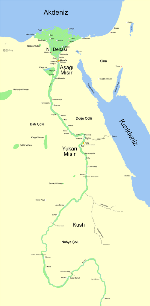
English: (Original description:) A map of ancient Egypt, made with Inkscape. The map shows the Nile up to the fifth cataract, and major cities and sites of the Dynastic period (c. 3150 BC to 30 BC). Cairo and Jerusalem are shown as reference cities.
Türkçe: Antik Mısır haritası. Harita Nil nehrini, nehir üzerindeki beş şelaleyi ve (MÖ 3150 ile 30 arası) Hanedan dönemindeki büyük kentleri ve siteleri gösterir. |
| Date | (of this version:08-14-08) |
| Source | File:Ancient Egypt map-en.svg |
| Author | Jeff Dahl |
| Other versions |
[]
|


Licensing edit
I, the copyright holder of this work, hereby publish it under the following licenses:
This file is licensed under the Creative Commons Attribution-Share Alike 3.0 Unported license.
- You are free:
- to share – to copy, distribute and transmit the work
- to remix – to adapt the work
- Under the following conditions:
- attribution – You must give appropriate credit, provide a link to the license, and indicate if changes were made. You may do so in any reasonable manner, but not in any way that suggests the licensor endorses you or your use.
- share alike – If you remix, transform, or build upon the material, you must distribute your contributions under the same or compatible license as the original.

|
Permission is granted to copy, distribute and/or modify this document under the terms of the GNU Free Documentation License, Version 1.2 or any later version published by the Free Software Foundation; with no Invariant Sections, no Front-Cover Texts, and no Back-Cover Texts. A copy of the license is included in the section entitled GNU Free Documentation License. |
You may select the license of your choice.
File history
Click on a date/time to view the file as it appeared at that time.
| Date/Time | Thumbnail | Dimensions | User | Comment | |
|---|---|---|---|---|---|
| current | 21:34, 15 August 2008 | | 1,577 × 3,219 (307 KB) | Kuara (talk | contribs) | |
| 10:52, 15 August 2008 |  | 1,577 × 3,219 (305 KB) | Kuara (talk | contribs) | {{Information |Description= |Source= |Date= |Author= |Permission= |other_versions= }} | |
| 10:32, 15 August 2008 |  | 1,577 × 3,219 (305 KB) | Kuara (talk | contribs) | ||
| 08:39, 15 August 2008 |  | 1,577 × 3,219 (305 KB) | Kuara (talk | contribs) | {{Information |Description= |Source= |Date= |Author= |Permission= |other_versions= }} | |
| 08:20, 15 August 2008 |  | 1,577 × 3,219 (306 KB) | Kuara (talk | contribs) | ||
| 00:27, 14 August 2008 |  | 1,577 × 3,219 (305 KB) | Kuara (talk | contribs) | {{Information |Description={{en|1=(Original description:) A map of ancient Egypt, made with Inkscape. The map shows the Nile up to the fifth cataract, and major cities and sites of the Dynastic period (c. 3150 BC to 30 BC). Cairo and Jerusalem are shown a |
You cannot overwrite this file.
File usage on Commons
The following 27 pages use this file:
- File:Ancient Egypt map-af.svg
- File:Ancient Egypt map-ar.png
- File:Ancient Egypt map-de.svg
- File:Ancient Egypt map-el.svg
- File:Ancient Egypt map-en.svg
- File:Ancient Egypt map-es.svg
- File:Ancient Egypt map-fr.svg
- File:Ancient Egypt map-hiero.svg
- File:Ancient Egypt map-it.svg
- File:Ancient Egypt map-la.png
- File:Ancient Egypt map-la.svg
- File:Ancient Egypt map-mk.svg
- File:Ancient Egypt map-nl.svg
- File:Ancient Egypt map-no.svg
- File:Ancient Egypt map-pl.svg
- File:Ancient Egypt map-pt.svg
- File:Ancient Egypt map-ru.svg
- File:Ancient Egypt map-sk.svg
- File:Ancient Egypt map-sr.svg
- File:Ancient Egypt map-vi.svg
- File:Ancient Egypt map-zh-hans.svg
- File:Antik Mısır haritası.png
- File:Antzinako Egipto.svg
- File:Mapo de antikva Egiptio.jpg
- File:Mapo de antikva Egiptio - centro.jpg
- File:Muistne Egiptus.png
- Template:Other versions/Ancient Egypt map
File usage on other wikis
The following other wikis use this file:
- Usage on tr.wikipedia.org
- Antik Mısır
- Kullanıcı mesaj:Yabancı/ Arşiv 6
- Vikipedi:Seçkin resim adayları/Arşiv/Ağustos 2008
- Vikipedi:Seçkin resim adayları/Antik Mısır haritası.png
- Kullanıcı mesaj:Gökhan/5
- Vikipedi:Günün seçkin resmi/Kasım 2008
- Şablon:GSR/2008-11-25
- Vikipedi:Seçkin resimler/Ana sayfaya çıkmış resimler/2008 listesi
- Vikipedi:Seçkin resimler/Çizimler, diyagramlar ve haritalar/Haritalar
- Aşağı Mısır
- Yukarı Mısır
- Vikipedi:Günün seçkin resmi/Ocak 2014
- Şablon:GSR/2014-01-15
- Vikipedi:Seçkin resimler/Ana sayfaya çıkmış resimler/2014 listesi
- Şablon:GSR/2017-05-05
- Vikipedi:Günün seçkin resmi/Mayıs 2017
- Şablon:GSR/2020-04-15
- Vikipedi:Günün seçkin resmi/Nisan 2020
- Usage on tr.wiktionary.org