File:Antiquities of Samarkand. Bridge of Shadman Malik. View from the West WDL3873.png

Size of this preview: 742 × 599 pixels. Other resolutions: 297 × 240 pixels | 594 × 480 pixels | 951 × 768 pixels | 1,268 × 1,024 pixels.
Original file (1,268 × 1,024 pixels, file size: 1.72 MB, MIME type: image/png)
Captions
Captions
Add a one-line explanation of what this file represents
Summary edit
| Author |
Русский: Богаевский, Николай Владимирович, 1843—1912 гг.
Français : Bogaevskii, Nikolaï V., 1843-1912
English: Bogaevskii, Nikolai V., 1843-1912
中文:亚历山大·L·坤,1840-1888 年
Português: Bogaevskii, Nikolai V., 1843-1912
العربية: بوغافسكي، نيكولاي ف.، 1843-1912
Español: Bogaevskii, Nikolai V., 1843-1912 |
| Title |
Русский: Самаркандские древности. Мост Шадман Малик. Вид с запада
Français : Antiquités de Samarcande. Pont de Shadman Malik. Vue depuis l'ouest
English: Antiquities of Samarkand. Bridge of Shadman Malik. View from the West
中文:撒马尔罕古迹。萨德曼·马利克大桥。从西面观看的景色
Português: Antiguidades de Samarcanda. Ponte de Shadman Malik. Vista do Oeste.
العربية: آثار سمرقند. جسر شادمان مالك. منظر من الغرب
Español: Antigüedades de Samarcanda. Puente de Shadman Malik. Vista desde el oeste |
| Description |
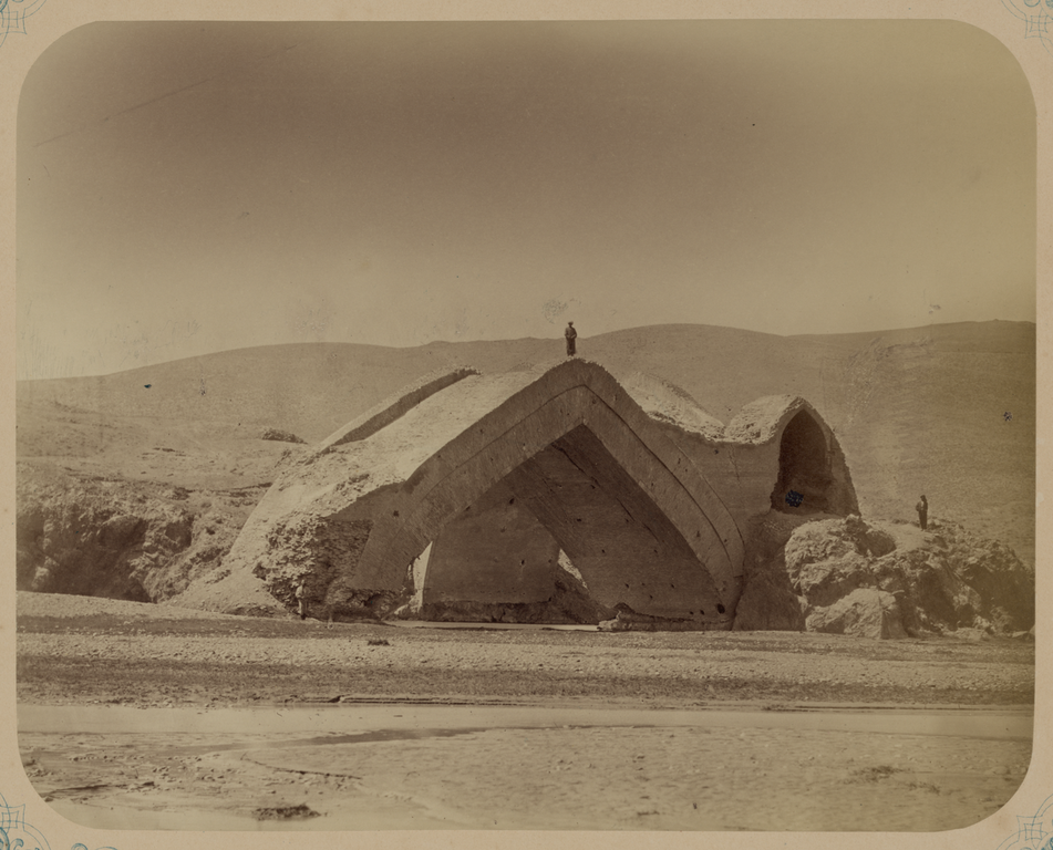
Русский: Эта фотография акведука на реке Зеравшан, на окраине Самарканда (Узбекистан), вид с запада, содержится в археологической части "Туркестанского альбома". Шеститомное фотографическое исследование было подготовлено и издано в 1871—1872 гг. под патронажем генерала Константина П. фон Кауфмана, первого генерал-губернатора (1867—1882 гг.) Туркестана, как называли в то время территорию Центральной Азии, принадлежавшую Российской империи. В альбоме уделяется особое внимание архитектурному наследию Самарканда. В альбоме эта конструкция названа мостом Шадаман Малик, но принятое название — это акведук на реке Зеравшан. Построенное в 1502 г., это монументальное строение служило ключевым элементом в местной оросительной сети. Оно не только обеспечивало подачу воды, но и распределяло ее по двум каналам. Две массивные арки соединены под непрямым углом, соответствующим разным каналам. Несмотря на внушительную конструкцию, акведук пострадал в результате землетрясений и многовековой запущенности. Его строительство особенно примечательно, если принять во внимание политическую нестабильность в начале XVI века, когда правление в Самарканде менялось в борьбе между Бабуром, прапраправнуком Тимура (Тамерлана), и Шейбани-ханом, основателем узбекской династии Шейбанидов. В 1500 г. и затем опять в 1505 г. Шейбани-хан захватил Самарканд, принадлежавший в то время Бабуру, в дальнейшем основавшему империю Великих Моголов.
Археологические объекты; Мосты; Любопытные события и чудеса; Фотографические исследования; Тюркские народы Français : Cette photographie de la vue ouest de l'aqueduc sur le fleuve Zeravchan, à proximité de Samarcande (Ouzbékistan), est extraite de l'ouvrage archéologique Album du Turkestan. Cet inventaire photographique, en six volumes, fut réalisé entre 1871 et 1872 sous le patronage du général Konstantin P. von Kaufman, premier gouverneur général (1867-1882) du Turkestan, nom donné aux territoires d'Asie centrale de l'Empire russe. L'album consacre une attention particulière à l'héritage de l'architecture de Samarcande. Si la légende de l'album identifie cette structure comme le pont de Shadman Malik, sa dénomination admise est l'aqueduc du fleuve Zeravchan. Construite en 1502, cette structure monumentale fut un élément essentiel du réseau d'irrigation local. Non seulement elle transportait de l'eau, mais elle la distribuait également via deux canaux. Les deux arches massives se rejoignent en un angle oblique, formant les différents canaux. Malgré sa construction impressionnante, l'aqueduc fut endommagé par les séismes et la négligence au fil des siècles. Sa construction est d'autant plus remarquable au vu de l'instabilité politique qui régnait au début du XVIe siècle, lorsque Samarcande changea de main durant une lutte entre Babur, arrière-petit-fils de Tamerlan, et Shaybani Khan, fondateur de la dynastie ouzbèque des Chaybanides. En 1500, et de nouveau en 1505, Shaybani Khan s'empara de Samarcande alors aux mains de Babur, et fonda par la suite l'Empire moghol.
Sites archéologiques; Ponts; Curiosités et merveilles; Inventaires photographiques; Peuples turciques English: This photograph of the west view of the aqueduct at the Zeravshan River, on the outskirts of Samarkand (Uzbekistan), is from the archeological part of Turkestan Album. The six-volume photographic survey was produced in 1871-72 under the patronage of General Konstantin P. von Kaufman, the first governor-general (1867-82) of Turkestan, as the Russian Empire’s Central Asian territories were called. The album devotes special attention to Samarkand’s architectural heritage. The album caption refers to this structure as the Shadman Malik Bridge, but the accepted designation is the Zeravshan River Aqueduct. Built in 1502, this monumental structure served as a key element in the local irrigation network. It not only carried water, but also distributed it into two channels. The two massive arches are joined at an oblique angle corresponding to the different channels. Despite its impressive construction, the aqueduct has suffered from seismic damage and neglect over the centuries. Its construction is all the more remarkable in view of the instability in the early 16th century, when Samarkand changed hands during a struggle between Babur, the great-great-great grandson of Timur (Tamerlane), and Shaybani Khan, founder of the Shaybanid Uzbek dynasty. In 1500, and again in 1505, Shaybani Khan captured Samarkand from Babur, who subsequently established the Mughal Empire.
Archaeological sites; Bridges; Curiosities and wonders; Photographic surveys; Turkic peoples 中文:这幅撒马尔罕(乌兹别克斯坦)远郊扎拉夫桑河水道桥的西面视角照片出自《土耳其斯坦相册》。这份六卷本摄影调查作品制作于 1871-72 年间,是在俄罗斯驻土耳其斯坦(俄罗斯帝国中亚属地的名称)的首任总督康斯坦丁·P·凡·考夫曼(Konstantin P. von Kaufman,1867-82 在位)赞助下完成的。相册特别展示了撒马尔罕的建筑遗产。相片的标题指出此建筑为萨德曼·马利克大桥 (Shadman Malik Bridge),但普遍接受的名称是扎拉夫桑河水道桥 (Zeravshan River Aqueduct)。这座巨大的建筑建于 1502 年,是当地灌溉网络中关键的一环。它不仅运送河水,还将河水分到两个水渠中。两个庞大的拱门通过一个斜角连接在一起,斜角的两边分别连接不同的水渠。尽管是一座令人印象深刻的建筑,但在长达几个世纪的时间里,这座水道桥一直遭受地震破坏、疏于管理。回顾 16 世纪初的动荡不安,当时的撒马尔罕几易其主,帖木儿的重重重孙巴布尔 (Babur) 与昔班尼乌兹别克王朝的建立者昔班尼汗 (Shaybani Khan) 争斗不休,更加让人感到修建这座建筑的不易。昔班尼汗曾先后于 1500 年和 1505 年从巴布尔手中夺得撒马尔罕,后者后来建立了莫卧儿帝国。
考古遗址; 桥梁; 稀世珍宝和奇观; 摄影勘察作品; 突厥人 Português: Esta fotografia da visão oeste do aqueduto no rio Zeravshan, na periferia de Samarcanda (Uzbequistão), faz parte da seção arqueológica do Álbum do Turquestão. O levantamento fotográfico em seis volumes foi produzido entre 1871 e 1872, sob o patrocínio do general Konstantin P. von Kaufman, o primeiro governador-geral (1867-1882) do Turquestão, nome dado aos territórios da Ásia Central do Império Russo. O álbum dedica atenção especial ao patrimônio arquitetônico de Samarcanda. A legenda do álbum se refere a essa estrutura como a Ponte de Shadman Malik, porém oficialmente chamado de Aqueduto do Rio Zeravshan. Construída em 1502, essa enorme estrutura serviu como elemento-chave para a rede de irrigação local. Além de o aqueduto transportar a água, ele também a distribuía em dois canais. Os dois arcos grandiosos são unidos por um ângulo oblíquo correspondendo a diferentes canais. Apesar de sua construção imponente, o aqueduto sofreu com abalos sísmicos e foi esquecido por séculos. Sua construção é ainda mais marcante em vista da instabilidade no começo do século XVI, quando a Samarcanda mudou de propriedade durante uma luta entre Babur, tataraneto de Timur (Tamerlão) e Shaybani Khan, fundador da dinastia uzbeque Shaybanid. Em 1500 e novamente em 1505, Shaybani Khan tomou Samarcanda de Babur, que posteriormente criou o Império Mongol.
Sítios arqueológicos; Pontes; Curiosidades e maravilhas; Levantamentos fotográficos; Povos túrquicos العربية: تُوجد هذه الصورة للجهة الغربية لقناة نهر زيرافشان على مشارف سمرقند (أوزبكستان) ضمن الجزء الأثري من ألبوم تُرْكِستان. يولي الألبوم اهتماماً خاصاً بالتراث المعماري بسمرقند. يُشير التعليق الموجود في الألبوم إلى هذا البناء باسم جسر شادمان مالك، في حين أن التسمية المتعارف عليها هي قناة نهر زيرافشان. كان هذا البناء التذكاري، الذي شُيد في عام 1502، يُعد أحد العناصر المهمة في شبكة الري المحلية. لم تكن القناة تنقل الماء فحسب، لكنها أيضًا كانت توزعه على قناتين فرعيتين. القوسان الضخمان يلتقيان بزاوية مائلة حسب اتجاه كل قناة. وعلى الرغم من روعة البناء، إلا أن أضرارًا لحقت بالقناة نجمت عن الزلزال والإهمال على مر القرون. يُمثل تشييد القناة في حد ذاته أمراً لافتاً، بالنظر إلى حالة عدم الاستقرار التي كانت سائدة في أوائل القرن السادس عشر، حيث تبدّلتْ السيطرة على سمرقند أثناء النزاع الذي دار بين بابُر، وهو حفيد الحفيد الأول لتيمور (تَيْمورلِنك)، وشيباني خان، مؤسس الأسرة الشيبانيانية الأزبكية. في عامي 1500 و1505، استولى شيباني خان على سمرقند من بابر، الذي أسس في نهاية الأمر الإمبراطورية المغولية في الهند.
المواقع الأثرية; الجسور; العجائب والمعجزات; البحوث التصويرية; الشعوب التركية Español: Esta fotografía de la vista desde el oeste del acueducto en el río Zeravshan, en las afueras de Samarcanda (Uzbekistán), proviene de la parte arqueológica del Álbum de Turquestán. El estudio fotográfico en seis volúmenes se produjo entre 1871 y 1872, bajo el patrocinio del general Konstantín P. von Kaufman, el primer gobernador general (1867-1882) de Turquestán, como se conocían a los territorios del Imperio ruso en Asia Central. En el álbum se presta especial atención a la herencia arquitectónica de Samarcanda. El epígrafe del álbum hace referencia a esta estructura como el puente de Shadman Malik, pero la designación aceptada es «el acueducto del río Zeravshan». Construida en 1502, esta estructura monumental sirvió como elemento clave en la red de riego local. No solo llevaba agua, sino que también la distribuía en dos canales. Los dos arcos enormes, que marcan los diferentes canales, se unen en un ángulo oblicuo. A pesar de su impresionante construcción, el acueducto ha sufrido el daño de la actividad sísmica de la zona y el abandono durante siglos. Su construcción es aún más notable en vista de la inestabilidad en el siglo XVI, cuando Samarcanda cambió de manos durante una lucha entre Babur, chozno de Tamerlán, y Shaybani Khan, fundador de la dinastía shaybánida de Uzbekistán. En el año 1500, y nuevamente en 1505, Shaybani Khan arrebató Samarcanda de manos de Babur, quien posteriormente instauró el Imperio mogol.
Sitios arqueológicos; Puentes; Curiosidades y maravillas; Estudios fotográficos; Pueblos túrquicos |
| Date | between 1868 and 1872 |
| Medium |
Русский: Эстампы, фотографии
Français : Images, photographies
English: Prints, Photographs
中文:图像, 摄影作品
Português: Imagens, Fotografias
العربية: مطبوعات، صور فوتوغرافية
Español: Imágenes, Fotografías |
| Dimensions |
English: 1 photographic print : albumen |
| Collection |
Русский: Библиотека Конгресса
Français : Bibliothèque du Congrès
English: Library of Congress
中文:国会图书馆
Português: Biblioteca do Congresso
العربية: مكتبة الكونغرس
Español: Biblioteca del Congreso |
| Current location |
Русский: Изображения из "Туркестанского альбома"
Français : Images de l'Album du Turkestan
English: Images from the Turkestan Album
中文:图片出自《土耳其斯坦相册》
Português: Imagens do Álbum do Turquestão
العربية: صور من ألبوم تُرْكِستان
Español: Imágenes del Álbum de Turquestán |
| Place of creation |
Русский: Самарканд
Français : Samarcande
English: Samarkand
中文:撒马尔罕
Português: Samarcanda
العربية: سمرقند
Español: Samarcanda |
| Notes |
Original language title: Самаркандския древности. Мост Шадман Малик. Вид с запада Русский: Иллюстрация в: Туркестанский альбом, Часть археологическая, 1871—1872 гг., часть 1, том 2, пластина 152.
Français : Illustration provenant de : Album du Turkestan, ouvrage archéologique, 1871-1872, partie 1, volume 2, planche 152.
English: Illustration in: Turkestan Album, Archaeological Part, 1871-1872, part 1, volume 2, plate 152.
中文:插图出自:《土耳其斯坦相册》,考古部分,1871-1872 年,第 1 部分,第 2 卷,第 152 页。
Português: Ilustração em: Álbum do Turquestão, seção arqueológica, 1871-1872, parte 1, volume 2, placa 152.
العربية: رسم إيضاحي في: ألبوم تُرْكِستان، الجزء الأثري، 1871-1872، الجزء الأول، المجلد الثاني، اللوحة 152.
Español: Ilustración en: Álbum de Turquestán, parte arqueológica, 1871-1872, parte 1, volumen 2, lámina 152. |
| References | http://hdl.loc.gov/loc.wdl/dlc.3873 |
| Source/Photographer |
|
Licensing edit
|
This is a faithful photographic reproduction of a two-dimensional, public domain work of art. The work of art itself is in the public domain for the following reason:
The official position taken by the Wikimedia Foundation is that "faithful reproductions of two-dimensional public domain works of art are public domain".
This photographic reproduction is therefore also considered to be in the public domain in the United States. In other jurisdictions, re-use of this content may be restricted; see Reuse of PD-Art photographs for details. | ||||
File history
Click on a date/time to view the file as it appeared at that time.
| Date/Time | Thumbnail | Dimensions | User | Comment | |
|---|---|---|---|---|---|
| current | 14:57, 2 March 2014 | | 1,268 × 1,024 (1.72 MB) | Fæ (talk | contribs) | =={{int:filedesc}}== {{Artwork |artist = |author ={{ru|1=Богаевский, Николай Владимирович, 1843—1912 гг.}} {{fr|1=Bogaevskii, Nikolaï V., 1843-1912}} {{en|1=Bogaevskii, Nikolai V., 1843-1912}} {{zh|1=亚历山大·L... |
You cannot overwrite this file.
File usage on Commons
The following 2 pages use this file: