File:Appalachian map.jpg
Size of this preview: 422 × 599 pixels. Other resolutions: 169 × 240 pixels | 432 × 613 pixels.
Original file (432 × 613 pixels, file size: 31 KB, MIME type: image/jpeg)
Captions
Captions
Add a one-line explanation of what this file represents
Summary edit
| Description |
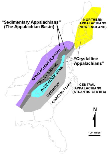
English: USGS map of the Appalachians |
| Date | 8 August 2005 (original upload date) |
| Source | http://3dparks.wr.usgs.gov/nyc/images/fig51.jpg (see also http://3dparks.wr.usgs.gov/nyc/common/captions.htm) |
| Author | USGS |
| Other versions |
Derivative works of this file: Appalachian map.svg:  |

|
File:Appalachian map.svg is a vector version of this file. It should be used in place of this JPG file when not inferior.
File:Appalachian map.jpg → File:Appalachian map.svg
For more information, see Help:SVG. |
|
Licensing edit
This image is in the public domain in the United States because it only contains materials that originally came from the United States Geological Survey, an agency of the United States Department of the Interior. For more information, see the official USGS copyright policy.
|
This file, which was originally posted to
http://3dparks.wr.usgs.gov/nyc/common/captions.htm, was reviewed on 5 May 2012 by reviewer Ralgis, who confirmed that it was available there under the stated license on that date.
|
Original upload log edit
The original description page was here. All following user names refer to en.wikipedia.
- 2007-01-24 13:39 Anon user 432×613× (32226 bytes) fixed spelling
- 2005-08-08 02:53 Vsmith 432×613× (56702 bytes) The Appalachians - USGS http://3dparks.wr.usgs.gov/nyc/images/fig51.jpg also http://3dparks.wr.usgs.gov/nyc/common/captions.htm {{PD-USGov-Interior-USGS}}
File history
Click on a date/time to view the file as it appeared at that time.
| Date/Time | Thumbnail | Dimensions | User | Comment | |
|---|---|---|---|---|---|
| current | 23:56, 4 May 2012 | | 432 × 613 (31 KB) | OgreBot (talk | contribs) | (BOT): Uploading old version of file from en.wikipedia; originally uploaded on 2007-01-24 13:39:03 by Anon user |
| 18:46, 5 February 2006 |  | 432 × 613 (55 KB) | Maksim (talk | contribs) | La bildo estas kopiita de wikipedia:en. La originala priskribo estas: The Appalachians - USGS http://3dparks.wr.usgs.gov/nyc/images/fig51.jpg also http://3dparks.wr.usgs.gov/nyc/common/captions.htm {{PD-USGov-Interior-USGS}} {| border="1" ! date/time |
You cannot overwrite this file.
File usage on Commons
The following 2 pages use this file:
File usage on other wikis
The following other wikis use this file:
- Usage on en.wikipedia.org