File:ApproachingNangaParbat.JPG

Size of this preview: 800 × 197 pixels. Other resolutions: 320 × 79 pixels | 640 × 158 pixels | 1,024 × 252 pixels | 3,652 × 900 pixels.
Original file (3,652 × 900 pixels, file size: 649 KB, MIME type: image/jpeg)
Captions
Captions
Add a one-line explanation of what this file represents
Summary edit
| Description |
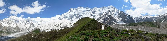
English: This panorama was taken on the way to the base camp of Nanga Parbat, also known as the "killer mountain". At 8,125 metres (26,658 feet), it is the 9th highest peak of the world and the 2nd highest peak in Pakistan. The base camp is about a kilometer's trek from here. One glacier is visible on the right side, another glacier can be seen building on the left side. |
| Source | Own work |
| Author | Waqas.usman |
Licensing edit
I, the copyright holder of this work, hereby publish it under the following licenses:

|
Permission is granted to copy, distribute and/or modify this document under the terms of the GNU Free Documentation License, Version 1.2 or any later version published by the Free Software Foundation; with no Invariant Sections, no Front-Cover Texts, and no Back-Cover Texts. A copy of the license is included in the section entitled GNU Free Documentation License. |
| This file is licensed under the Creative Commons Attribution-Share Alike 3.0 Unported license. | ||
| ||
| This licensing tag was added to this file as part of the GFDL licensing update. |
This file is licensed under the Creative Commons Attribution 2.5 Generic license.
- You are free:
- to share – to copy, distribute and transmit the work
- to remix – to adapt the work
- Under the following conditions:
- attribution – You must give appropriate credit, provide a link to the license, and indicate if changes were made. You may do so in any reasonable manner, but not in any way that suggests the licensor endorses you or your use.
You may select the license of your choice.
Assessment edit
|
| Annotations | This image is annotated: View the annotations at Commons |
File history
Click on a date/time to view the file as it appeared at that time.
| Date/Time | Thumbnail | Dimensions | User | Comment | |
|---|---|---|---|---|---|
| current | 00:02, 30 November 2005 | 3,652 × 900 (649 KB) | Waqas.usman (talk | contribs) | This panorama was taken on the way to the base camp of Nanga Parbat, also known as the "killer mountain", the 9th highest peak of the world and the 2nd highest peak in Pakistan. The base camp is about a kilometer's trek from here. One glacier is v |
You cannot overwrite this file.
File usage on Commons
The following 6 pages use this file:
File usage on other wikis
The following other wikis use this file:
- Usage on ar.wikipedia.org
- Usage on ast.wikipedia.org
- Usage on bg.wikipedia.org
- Usage on bh.wikipedia.org
- Usage on bs.wikipedia.org
- Usage on ca.wikipedia.org
- Usage on de.wikipedia.org
- Usage on de.wiktionary.org
- Usage on en.wikipedia.org
- Portal:Pakistan
- User talk:Waqas.usman
- Wikipedia:Featured pictures/Places/Panorama
- Portal:Pakistan/Selected picture/Archive
- Portal:Pakistan/Selected picture/7
- Portal:Pakistan/Selected picture
- User:Charlie Tango Bravo
- Wikipedia:Featured pictures thumbs/28
- Wikipedia:Featured picture candidates/September-2011
- Wikipedia:Featured picture candidates/File:ApproachingNangaParbat.JPG
- Wikipedia:Wikipedia Signpost/2011-09-12/Featured content
- User talk:Crisco 1492/Archive 8
- Portal:Asia/Selected panorama
- Portal:Asia/Selected panorama/1
- Template:POTD/2013-02-01
- Wikipedia:Picture of the day/February 2013
- Wikipedia:Main Page history/2013 February 1
- Wikipedia:Featured picture candidates/delist/2013
- Wikipedia:Featured picture candidates/delist/Approaching Nanga Parbat
- Talk:Nanga Parbat/Archive 1
- Wikipedia:Wikipedia Signpost/Single/2011-09-12
- Portal:Pakistan/Recognized content
- Usage on es.wikipedia.org
- Usage on fa.wikipedia.org
- Usage on fi.wikipedia.org
- Usage on fr.wikipedia.org
- Usage on hr.wikipedia.org
- Usage on hu.wikipedia.org
- Usage on it.wikipedia.org
- Usage on it.wikivoyage.org
- Usage on kk.wikipedia.org
- Usage on kn.wikipedia.org
- Usage on ko.wikipedia.org
- Usage on mr.wikipedia.org
- Usage on nn.wikipedia.org
- Usage on no.wikipedia.org
View more global usage of this file.