File:Aranislandssatmap.jpg
No higher resolution available.
Aranislandssatmap.jpg (555 × 352 pixels, file size: 115 KB, MIME type: image/jpeg)
Captions
Captions
Add a one-line explanation of what this file represents
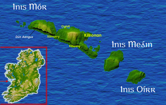
Aran Islands map from sat. Personal image amended from sat page here
Author Kanchelskis.

|
Permission is granted to copy, distribute and/or modify this document under the terms of the GNU Free Documentation License, Version 1.2 or any later version published by the Free Software Foundation; with no Invariant Sections, no Front-Cover Texts, and no Back-Cover Texts. A copy of the license is included in the section entitled GNU Free Documentation License. |
| This file is licensed under the Creative Commons Attribution-Share Alike 3.0 Unported license. | ||
| ||
| This licensing tag was added to this file as part of the GFDL licensing update. |

|
This locator map image could be re-created using vector graphics as an SVG file. This has several advantages; see Commons:Media for cleanup for more information. If an SVG form of this image is available, please upload it and afterwards replace this template with
{{vector version available|new image name}}.
It is recommended to name the SVG file “Aranislandssatmap.svg”—then the template Vector version available (or Vva) does not need the new image name parameter. |

File history
Click on a date/time to view the file as it appeared at that time.
| Date/Time | Thumbnail | Dimensions | User | Comment | |
|---|---|---|---|---|---|
| current | 10:39, 27 June 2005 | | 555 × 352 (115 KB) | Kanchelskis (talk | contribs) | better version |
| 08:02, 27 June 2005 |  | 555 × 352 (116 KB) | Kanchelskis (talk | contribs) | Aran Islands map from sat. Personal image amended from sat page [http://commons.wikimedia.org/wiki/Image:Topography_Ireland.jpg here] Author Kanchelskis. {{GFDL}} |
You cannot overwrite this file.
File usage on Commons
The following page uses this file:
File usage on other wikis
The following other wikis use this file:
- Usage on br.wikipedia.org
- Usage on cy.wikipedia.org
- Usage on da.wikipedia.org
- Usage on el.wikipedia.org
- Usage on en.wikipedia.org
- Usage on es.wikipedia.org
- Usage on et.wikipedia.org
- Usage on fi.wikipedia.org
- Usage on fr.wikipedia.org
- Usage on ga.wikipedia.org
- Usage on it.wikipedia.org
- Usage on it.wikivoyage.org
- Usage on la.wikipedia.org
- Usage on mt.wikipedia.org
- Usage on nds.wikipedia.org
- Usage on pl.wikipedia.org
- Usage on zh.wikipedia.org