File:Area51 Aerial photograph.jpg

Size of this preview: 800 × 573 pixels. Other resolutions: 320 × 229 pixels | 640 × 458 pixels | 936 × 670 pixels.
Original file (936 × 670 pixels, file size: 377 KB, MIME type: image/jpeg)
Captions
Captions
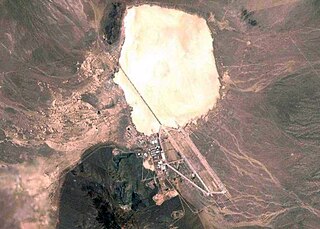
Satellite imagery of Area 51 from NASA's Landsat-7
Summary edit
| Description |
Deutsch: Landsat-7-Aufnahme der NASA aus World Wind |
| Date | 25 March 2005 (original upload date) |
| Source | Transferred from de.wikipedia to Commons. |
| Author | The original uploader was Sansculotte at German Wikipedia. |
| Permission (Reusing this file) |
PD-USGov. |
Licensing edit
| This image is in the public domain because it is a screenshot from NASA’s globe software World Wind using a public domain layer, such as Blue Marble, MODIS, Landsat, SRTM, USGS or GLOBE.
|
 |
Original upload log edit
The original description page was here. All following user names refer to de.wikipedia.
- 2005-03-25 19:12 Asselprinz 936×670× (386057 bytes) Landsat-7-Aufnahme der NASA aus [[World Wind]] (Farb- und Tonwertkorrektur von Simon Zwick)
- 2005-02-11 04:59 Sansculotte 936×670× (78512 bytes) {{Bild-pd}}, Landsat-7-Aufnahme der NASA aus [[World Wind]]
File history
Click on a date/time to view the file as it appeared at that time.
| Date/Time | Thumbnail | Dimensions | User | Comment | |
|---|---|---|---|---|---|
| current | 08:41, 2 June 2009 | | 936 × 670 (377 KB) | Nachcommonsverschieber (talk | contribs) | version by de:user:Asselprinz |
| 08:40, 2 June 2009 |  | 936 × 670 (77 KB) | Nachcommonsverschieber (talk | contribs) | {{Information |Description={{de|Landsat-7-Aufnahme der NASA aus de:World Wind}} |Source=Transferred from [http://de.wikipedia.org de.wikipedia] |Date={{Date|2005|03|25}} (first version); {{Date|2005|02|11}} (last version) |Author=Original uploader w |
You cannot overwrite this file.
File usage on Commons
There are no pages that use this file.
File usage on other wikis
The following other wikis use this file:
- Usage on af.wikipedia.org
- Usage on ar.wikipedia.org
- Usage on bn.wikipedia.org
- Usage on cs.wikipedia.org
- Usage on el.wikipedia.org
- Usage on en.wikipedia.org
- Usage on fa.wikipedia.org
- Usage on fr.wikipedia.org
- Usage on ko.wikipedia.org
- Usage on pt.wikipedia.org
- Usage on ro.wikipedia.org
- Usage on simple.wikipedia.org
- Usage on sk.wikipedia.org
- Usage on sv.wikipedia.org
- Usage on th.wikipedia.org
- Usage on uk.wikipedia.org
- Usage on vi.wikipedia.org
- Usage on zh.wikipedia.org