File:Arealo de Malfrua prunuso.pdf

Size of this JPG preview of this PDF file: 463 × 599 pixels. Other resolutions: 185 × 240 pixels | 371 × 480 pixels | 593 × 768 pixels | 1,275 × 1,650 pixels.
Original file (1,275 × 1,650 pixels, file size: 748 KB, MIME type: application/pdf)
Captions
Captions
Add a one-line explanation of what this file represents
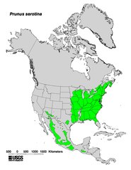
| Description | Range map of Prunus serotina | |||
| Date | ||||
| Source | Digital representation of "Atlas of United States Trees" by Elbert L. Little, Jr. [1] | |||
| Author | U.S. Geological Survey | |||
| Permission (Reusing this file) |
|
File history
Click on a date/time to view the file as it appeared at that time.
| Date/Time | Thumbnail | Dimensions | User | Comment | |
|---|---|---|---|---|---|
| current | 13:26, 25 January 2011 |  | 1,275 × 1,650 (748 KB) | Forstbirdo (talk | contribs) | {{Information |Description=Range map of Prunus serotina |Source=Digital representation of "Atlas of United States Trees" by Elbert L. Little, Jr. [http://esp.cr.usgs.gov/data/atlas/little/] |Date=1999 |Author=U.S. Geological Survey |Permission={{PD-USGov- |
You cannot overwrite this file.
File usage on Commons
There are no pages that use this file.