File:Argentina politico.svg

Size of this PNG preview of this SVG file: 363 × 599 pixels. Other resolutions: 145 × 240 pixels | 291 × 480 pixels | 465 × 768 pixels | 621 × 1,024 pixels | 1,241 × 2,048 pixels | 568 × 937 pixels.
Original file (SVG file, nominally 568 × 937 pixels, file size: 180 KB)
Captions
Captions
Add a one-line explanation of what this file represents
| Description |
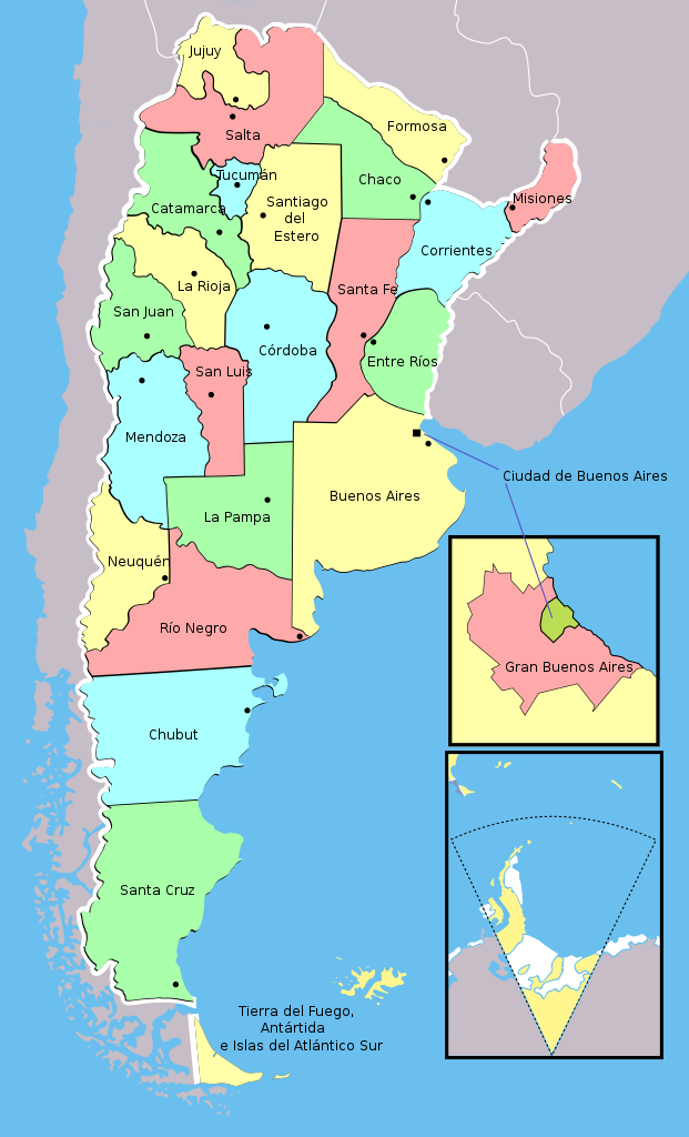
Español: Mapa político de Argentina, con las provincias en diferentes colores.
Se agregó un recuadro con el detalle de la Ciudad de Buenos Aires y el Gran Buenos Aires. Optimizado para uso web, con los ID de las provincias correspondientes a el código ISO 3166-2:AR. English: Political map of Argentina and Great Buenos Aires. Optimized to used in webs, within province's ID's according ISO 3166-2:AR |
| Date | (UTC) |
| Source | |
| Author |
|
| This is a retouched picture, which means that it has been digitally altered from its original version. Modifications: Separación y coloreo de las provincias, optimización para web. ID de provincias con código ISO 3166-2:AR. The original can be viewed here: Argentina.svg:
|
I, the copyright holder of this work, hereby publish it under the following licenses:
This file is licensed under the Creative Commons Attribution-Share Alike 3.0 Unported, 2.5 Generic, 2.0 Generic and 1.0 Generic license.
- You are free:
- to share – to copy, distribute and transmit the work
- to remix – to adapt the work
- Under the following conditions:
- attribution – You must give appropriate credit, provide a link to the license, and indicate if changes were made. You may do so in any reasonable manner, but not in any way that suggests the licensor endorses you or your use.
- share alike – If you remix, transform, or build upon the material, you must distribute your contributions under the same or compatible license as the original.

|
Permission is granted to copy, distribute and/or modify this document under the terms of the GNU Free Documentation License, Version 1.2 or any later version published by the Free Software Foundation; with no Invariant Sections, no Front-Cover Texts, and no Back-Cover Texts. A copy of the license is included in the section entitled GNU Free Documentation License. |
You may select the license of your choice.
Original upload log edit
This image is a derivative work of the following images:
- File:Argentina.svg licensed with Cc-by-sa-3.0,2.5,2.0,1.0, GFDL
- 2010-02-21T18:47:21Z Andres Rojas 568x937 (662608 Bytes) {{Information |Description={{es|1=Mapa político de la República Argentina}} |Source={{own}} |Author=[[User:Andres Rojas|Andres Rojas]] |Date= |Permission= |other_versions= }} [[Category:Maps]]
- 2010-02-21T04:57:52Z Andres Rojas 568x937 (641523 Bytes) {{Information |Description={{es|1=Argentina. Provincias y sus nombres.}} |Source={{own}} |Author=[[User:Andres Rojas|Andres Rojas]] |Date= |Permission= |other_versions= }} [[Category:Maps]]
- 2010-02-19T18:58:33Z Andres Rojas 568x937 (442453 Bytes) {{Information |Description=Political Map of Argentina |Source={{own}} |Date=2010-02-19 |Author= [[User:Andres Rojas|Andres Rojas]] |Permission= |other_versions= }} [[Category:Maps]]
Uploaded with derivativeFX
This image has been assessed using the Quality image guidelines and is considered a Quality image.
|
File history
Click on a date/time to view the file as it appeared at that time.
| Date/Time | Thumbnail | Dimensions | User | Comment | |
|---|---|---|---|---|---|
| current | 18:35, 23 April 2020 | | 568 × 937 (180 KB) | Ezarate (talk | contribs) | unicode fixed |
| 20:00, 18 February 2011 |  | 568 × 937 (180 KB) | Almendromaestro (talk | contribs) | {{Information |Description=Mapa político de Argentina, con las provincias en diferentes colores. Se agregó un recuadro con el detalle de la Ciudad de Buenos Aires y el Gran Buenos Aires. Optimizado para uso web, con los ID de las provincias correspondi |
You cannot overwrite this file.
File usage on Commons
The following 3 pages use this file:
File usage on other wikis
The following other wikis use this file:
- Usage on en.wikipedia.org
- Usage on fa.wikipedia.org
- Usage on id.wikipedia.org
- Usage on io.wikipedia.org
- Usage on ny.wikipedia.org
- Usage on simple.wikipedia.org
- Usage on tr.wikipedia.org
- Buenos Aires
- Santa Cruz (eyalet)
- Kategori:Buenos Aires
- Buenos Aires (eyalet)
- Kategori:Arjantin'in eyaletleri
- Catamarca (eyalet)
- Chaco (eyalet)
- Şablon:Arjantin'in eyaletleri
- Chubut (eyalet)
- Córdoba (eyalet)
- Corrientes (eyalet)
- Kategori:Córdoba eyaleti
- Kategori:Santa Cruz (eyalet)
- Río Negro (eyalet)
- Kategori:Chubut eyaleti
- Kategori:Catamarca eyaleti
- Kategori:Salta eyaleti
- Kategori:Mendoza eyaleti
- Kategori:Santa Fe eyaleti
- Kategori:Buenos Aires eyaleti
- Kategori:Ateş Toprakları, Antarktika ve Güney Atlantik Adaları
- Kategori:San Luis eyaleti
- Kategori:Río Negro eyaleti
- Kategori:Corrientes eyaleti
- Kategori:Chaco eyaleti
- Kategori:Misiones eyaleti
- La Rioja (eyalet)
- Tucumán (eyalet)
- Ateş Toprakları, Antarktika ve Güney Atlantik Adaları
- Santiago del Estero (eyalet)
- Santa Fe (eyalet)
- San Luis (eyalet)
- San Juan (eyalet)
- Salta (eyalet)
- Neuquén (eyalet)
- Misiones (eyalet)
- Mendoza (eyalet)
- La Pampa (eyalet)
- Jujuy (eyalet)
- Formosa (eyalet)
- Entre Ríos (eyalet)
- Kategori:San Juan eyaleti
- Kategori:Jujuy eyaleti