File:Armorican Massif geological map-fr.svg

Size of this PNG preview of this SVG file: 800 × 588 pixels. Other resolutions: 320 × 235 pixels | 640 × 470 pixels | 1,024 × 752 pixels | 1,280 × 940 pixels | 2,560 × 1,880 pixels | 1,770 × 1,300 pixels.
Original file (SVG file, nominally 1,770 × 1,300 pixels, file size: 981 KB)
Captions
Captions
Add a one-line explanation of what this file represents
Summary edit
| Description |
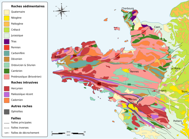
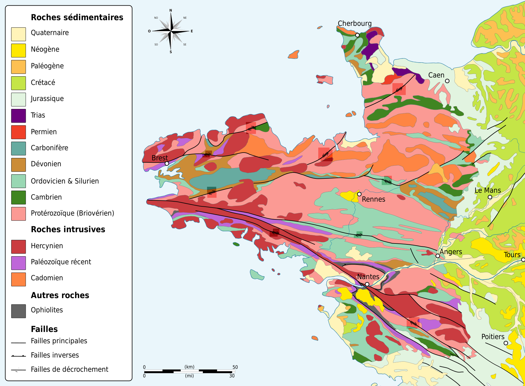
English: Geologic map of the Armorican Massif (NW France).
Français : Carte géologique du massif armoricain, France. |
||||||
| Date | (UTC) | ||||||
| Source |
Geologic_map_Armorican_Massif_EN.svg, itself from :
|
||||||
| Author |
|
||||||
| Other versions |
| ||||||
| SVG | W3C-validity not checked.
I, the copyright holder of this work, hereby publish it under the following licenses: This file is licensed under the Creative Commons Attribution-Share Alike 3.0 Unported license.
You may select the license of your choice. |
||||||
| Graphic Lab |


| Camera location | | View this and other nearby images on: OpenStreetMap |
|---|
Licensing edit
I, the copyright holder of this work, hereby publish it under the following licenses:
| Copyleft: This work of art is free; you can redistribute it and/or modify it according to terms of the Free Art License. You will find a specimen of this license on the Copyleft Attitude site as well as on other sites. |
This file is licensed under the Creative Commons Attribution-Share Alike 4.0 International, 3.0 Unported, 2.5 Generic, 2.0 Generic and 1.0 Generic license.
- You are free:
- to share – to copy, distribute and transmit the work
- to remix – to adapt the work
- Under the following conditions:
- attribution – You must give appropriate credit, provide a link to the license, and indicate if changes were made. You may do so in any reasonable manner, but not in any way that suggests the licensor endorses you or your use.
- share alike – If you remix, transform, or build upon the material, you must distribute your contributions under the same or compatible license as the original.
You may select the license of your choice.
Original upload log edit
This image is a derivative work of the following images:
- File:Geologic_map_Armorican_Massif_EN.svg licensed with Cc-by-sa-3.0, GFDL
- 2009-03-04T13:37:07Z Woudloper 1770x1340 (1861924 Bytes) {{Information |Description={{en|1=Geologic map of the Armorican Massif (NW France). Based on: *{{aut|Service Géologique National}}; '''1996''': ''Carte géologique de la France au millionième'', Éditions BRGM (6e druk), P
Uploaded with derivativeFX
File history
Click on a date/time to view the file as it appeared at that time.
| Date/Time | Thumbnail | Dimensions | User | Comment | |
|---|---|---|---|---|---|
| current | 09:52, 26 May 2014 | | 1,770 × 1,300 (981 KB) | Sémhur (talk | contribs) | Valid SVG |
| 17:55, 8 June 2009 |  | 1,770 × 1,300 (981 KB) | Sémhur (talk | contribs) | {{Information |Description= {{en|1=Geologic map of the Armorican Massif (NW France).}} {{fr|1=Carte géologique du massif armoricain, France.}} |Source=File:Geologic_map_Armorican_Massif_EN.svg, itself from : *{{Small-caps| |
You cannot overwrite this file.
File usage on Commons
There are no pages that use this file.
File usage on other wikis
The following other wikis use this file:
- Usage on en.wikipedia.org
- Usage on fr.wikipedia.org