File:Arram Beck - geograph.org.uk - 470029.jpg
No higher resolution available.
Arram_Beck_-_geograph.org.uk_-_470029.jpg (640 × 454 pixels, file size: 85 KB, MIME type: image/jpeg)
Captions
Captions
Add a one-line explanation of what this file represents
Summary edit
| Description |
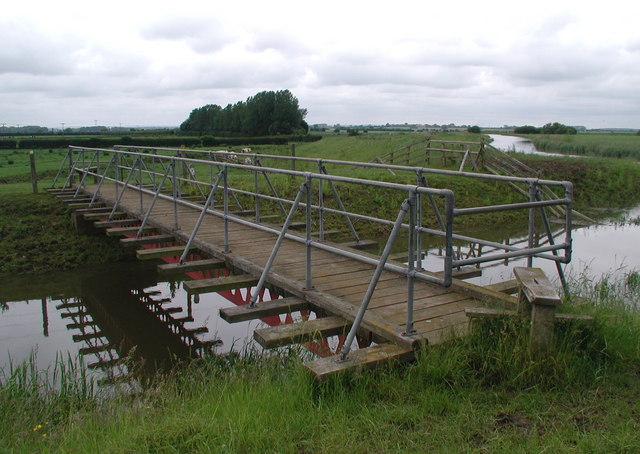
English: Arram Beck, east of Arram, East Riding of Yorkshire, England. Bridge over Arram Beck between the Beverley & Barmston Drain and the River Hull, with a stile at each end to prevent cattle wandering across. There's a bridleway here too - presumably horses are required either to jump the barriers on the bridge or take the plunge into the beck. |
| Date | |
| Source | From geograph.org.uk |
| Author | Paul Glazzard |
| Permission (Reusing this file) |
Creative Commons Attribution Share-alike license 2.0 |
| Attribution (required by the license) | Paul Glazzard / Arram Beck / |
| Camera location | | View this and other nearby images on: OpenStreetMap |
|---|
_heading:0.00&language=en)
| Object location | | View this and other nearby images on: OpenStreetMap |
|---|
_heading:0.00&language=en)
Licensing edit

|
This image was taken from the Geograph project collection. See this photograph's page on the Geograph website for the photographer's contact details. The copyright on this image is owned by Paul Glazzard and is licensed for reuse under the Creative Commons Attribution-ShareAlike 2.0 license.
|
This file is licensed under the Creative Commons Attribution-Share Alike 2.0 Generic license.
Attribution: Paul Glazzard
- You are free:
- to share – to copy, distribute and transmit the work
- to remix – to adapt the work
- Under the following conditions:
- attribution – You must give appropriate credit, provide a link to the license, and indicate if changes were made. You may do so in any reasonable manner, but not in any way that suggests the licensor endorses you or your use.
- share alike – If you remix, transform, or build upon the material, you must distribute your contributions under the same or compatible license as the original.
File history
Click on a date/time to view the file as it appeared at that time.
| Date/Time | Thumbnail | Dimensions | User | Comment | |
|---|---|---|---|---|---|
| current | 21:31, 4 February 2011 | | 640 × 454 (85 KB) | GeographBot (talk | contribs) | == {{int:filedesc}} == {{Information |description={{en|1=Arram Beck Bridge over Arram Beck between the Beverley & Barmston Drain and the River Hull, with a stile at each end to prevent cattle wandering across. There's a bridleway here too - presumably hor |
You cannot overwrite this file.
File usage on Commons
The following page uses this file:
File usage on other wikis
The following other wikis use this file:
- Usage on da.wikipedia.org
- Usage on en.wikipedia.org
- Usage on www.wikidata.org