File:Arrondissement Neufchâteau Belgium Map.png
No higher resolution available.
Arrondissement_Neufchâteau_Belgium_Map.png (220 × 290 pixels, file size: 5 KB, MIME type: image/png)
Captions
Captions
Add a one-line explanation of what this file represents
Summary edit
| Description |
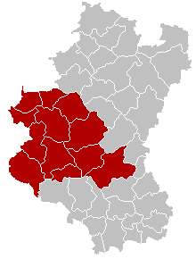
English: Map of Neufchâteau District in province of Luxembourg, Belgium.
Colors changed by me, based on work from w:nl:Gebruiker:LennartBolks/kaartenhoekje also in PD. Français : Carte indiquant la localisation de l'arrondissement de Neufchâteau dans la province de Luxembourg. |
| Source | Own work |
| Author | LennartBolks, colors by Nicnac25 |
Licensing edit
| This work has been released into the public domain by its author, LennartBolks. This applies worldwide. In some countries this may not be legally possible; if so: |
File history
Click on a date/time to view the file as it appeared at that time.
| Date/Time | Thumbnail | Dimensions | User | Comment | |
|---|---|---|---|---|---|
| current | 19:13, 26 February 2005 | | 220 × 290 (5 KB) | Nicnac25~commonswiki (talk | contribs) | Map of Neufchâteau District in province of Luxembourg, Belgium |
You cannot overwrite this file.
File usage on Commons
The following page uses this file:
File usage on other wikis
The following other wikis use this file:
- Usage on bg.wikipedia.org
- Usage on br.wikipedia.org
- Usage on bs.wikipedia.org
- Usage on ceb.wikipedia.org
- Usage on cs.wikipedia.org
- Usage on de.wikipedia.org
- Usage on es.wikipedia.org
- Usage on et.wikipedia.org
- Usage on fa.wikipedia.org
- Usage on frr.wikipedia.org
- Usage on hr.wikipedia.org
- Usage on hu.wikipedia.org
- Usage on it.wikipedia.org
- Usage on ja.wikipedia.org
- Usage on lb.wikipedia.org
- Usage on li.wikipedia.org
- Usage on lv.wikipedia.org
- Usage on nl.wikipedia.org
- Usage on no.wikipedia.org
- Usage on pt.wikipedia.org
- Usage on ru.wikipedia.org
- Usage on sh.wikipedia.org
- Usage on simple.wikipedia.org
- Usage on sv.wikipedia.org
- Usage on th.wikipedia.org
- Usage on vec.wikipedia.org
- Usage on vi.wikipedia.org
- Usage on vls.wikipedia.org
- Usage on wa.wikipedia.org
- Usage on www.wikidata.org