File:Arrondissements et cantons du Finistère.svg

Size of this PNG preview of this SVG file: 644 × 600 pixels. Other resolutions: 258 × 240 pixels | 515 × 480 pixels | 825 × 768 pixels | 1,100 × 1,024 pixels | 2,199 × 2,048 pixels | 1,310 × 1,220 pixels.
Original file (SVG file, nominally 1,310 × 1,220 pixels, file size: 192 KB)
Captions
Captions
Add a one-line explanation of what this file represents
| Description |
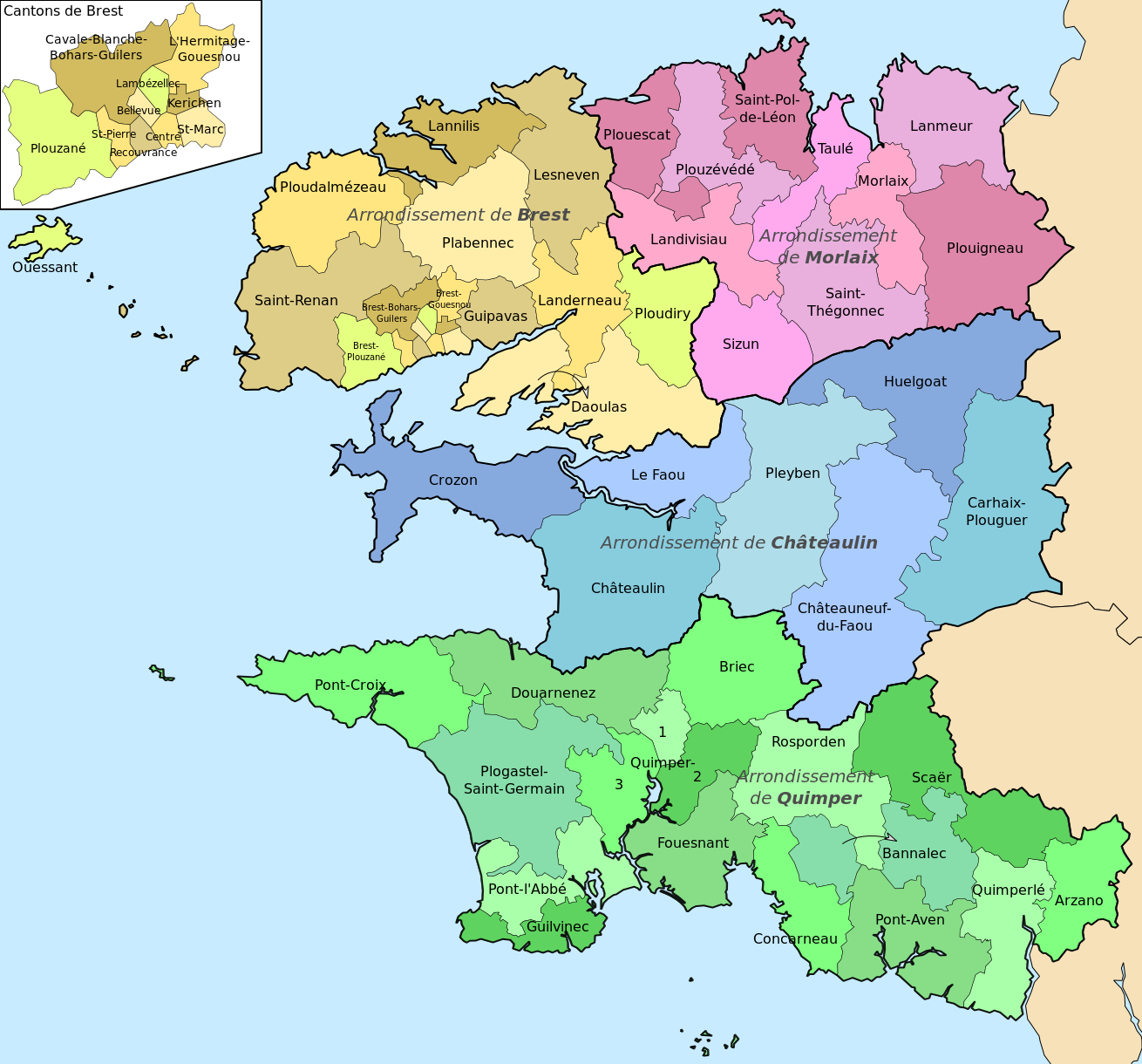
English: Map of arrondissements and cantons of the Finistère department. Français : Carte des arrondissements et cantons du Finistère. |
| Date | (UTC) |
| Source | |
| Author |
|
| Other versions |
Derivative works of this file: |
I, the copyright holder of this work, hereby publish it under the following licenses:
This file is licensed under the Creative Commons Attribution-Share Alike 3.0 Unported, 2.5 Generic, 2.0 Generic and 1.0 Generic license.
- You are free:
- to share – to copy, distribute and transmit the work
- to remix – to adapt the work
- Under the following conditions:
- attribution – You must give appropriate credit, provide a link to the license, and indicate if changes were made. You may do so in any reasonable manner, but not in any way that suggests the licensor endorses you or your use.
- share alike – If you remix, transform, or build upon the material, you must distribute your contributions under the same or compatible license as the original.

|
Permission is granted to copy, distribute and/or modify this document under the terms of the GNU Free Documentation License, Version 1.2 or any later version published by the Free Software Foundation; with no Invariant Sections, no Front-Cover Texts, and no Back-Cover Texts. A copy of the license is included in the section entitled GNU Free Documentation License. |
You may select the license of your choice.
Original upload log edit
This image is a derivative work of the following images:
- File:Map-France-Finistère-Commune-blank.svg licensed with Cc-by-sa-3.0,2.5,2.0,1.0, GFDL
- 2011-01-13T11:26:35Z Ju gatsu mikka 1468x1246 (213728 Bytes) == {{int:filedesc}} == {{Information |Description={{en|1=Map of the borders of communes in Finistère, France}} {{fr|1=Carte des limites de communes du Finistère}} |Source={{own}} |Author=[[User:Ju gatsu mikka|Ju gatsu
Uploaded with derivativeFX
File history
Click on a date/time to view the file as it appeared at that time.
| Date/Time | Thumbnail | Dimensions | User | Comment | |
|---|---|---|---|---|---|
| current | 21:30, 18 April 2011 | | 1,310 × 1,220 (192 KB) | Pymouss (talk | contribs) | typo |
| 21:18, 18 April 2011 |  | 1,310 × 1,220 (182 KB) | Pymouss (talk | contribs) | {{Information |Description={{en|1=Map of arrondissements and en:cantons of the Finistère department.}} {{fr|1=Carte des arrondissements et fr:cantons du Finistère.}} |Source=*File:Map-France-Finistère-Commune-blank.svg |Date=2011-04-1 |
You cannot overwrite this file.
File usage on Commons
The following 54 pages use this file:
- File:Cantons du Finistère Brest-Saint-Marc.svg
- File:Cantons du Finistère Brest-Saint-Pierre.svg
- File:Cantons du Finistère Brest Bellevue.svg
- File:Cantons du Finistère Brest Cavale-Blanche-Bohars-Guilers.svg
- File:Cantons du Finistère Brest Kerichen.svg
- File:Cantons du Finistère Brest L'Hermitage-Gouesnou.svg
- File:Cantons du Finistère Brest Lambézellec.svg
- File:Cantons du Finistère Brest centre.svg
- File:Cantons du Finistère Brest plouzane.svg
- File:Cantons du Finistère Brest recouvrance.svg
- File:Cantons du Finistère Briec.svg
- File:Cantons du Finistère Carhaix-Plouger.svg
- File:Cantons du Finistère Chateaulin.svg
- File:Cantons du Finistère Chateauneuf-du-Faou.svg
- File:Cantons du Finistère Concarneau.svg
- File:Cantons du Finistère Crozon.svg
- File:Cantons du Finistère Daoulas.svg
- File:Cantons du Finistère Douarnenez.svg
- File:Cantons du Finistère Fouesnant.svg
- File:Cantons du Finistère Guilvinec.svg
- File:Cantons du Finistère Guipavas.svg
- File:Cantons du Finistère Huelgoat.svg
- File:Cantons du Finistère Landerneau.svg
- File:Cantons du Finistère Landivisiau.svg
- File:Cantons du Finistère Lanmeur.svg
- File:Cantons du Finistère Lannilis.svg
- File:Cantons du Finistère Le Faou.svg
- File:Cantons du Finistère Lesneven.svg
- File:Cantons du Finistère Morlaix.svg
- File:Cantons du Finistère Ouessant.svg
- File:Cantons du Finistère Plabennec.svg
- File:Cantons du Finistère Pleyben.svg
- File:Cantons du Finistère Plogastel-Saint-Germain.svg
- File:Cantons du Finistère Ploudalmézeau.svg
- File:Cantons du Finistère Ploudiry.svg
- File:Cantons du Finistère Plouescat.svg
- File:Cantons du Finistère Plouigneau.svg
- File:Cantons du Finistère Plouzévédé.svg
- File:Cantons du Finistère Pont-Aven.svg
- File:Cantons du Finistère Pont-Croix.svg
- File:Cantons du Finistère Pont-l'Abbé.svg
- File:Cantons du Finistère Quimper I.svg
- File:Cantons du Finistère Quimper II.svg
- File:Cantons du Finistère Quimper III.svg
- File:Cantons du Finistère Quimperlé.svg
- File:Cantons du Finistère Rosporden.svg
- File:Cantons du Finistère Saint-Pol-de-Léon.svg
- File:Cantons du Finistère Saint-Renan.svg
- File:Cantons du Finistère Saint-Thégonnec.svg
- File:Cantons du Finistère Scaer.svg
- File:Cantons du Finistère Sizun.svg
- File:Cantons du Finistère Taulé.svg
- File:Cantons du Finistère azano.svg
- File:Cantons du Finistère bannalec.svg
File usage on other wikis
The following other wikis use this file:
- Usage on ca.wikipedia.org
- Usage on eo.wikipedia.org
- Usage on es.wikipedia.org
- Usage on fr.wikipedia.org