File:Assateague LOC 79690323.jpg

Size of this preview: 800 × 346 pixels. Other resolutions: 320 × 138 pixels | 640 × 277 pixels | 1,024 × 443 pixels | 1,280 × 553 pixels | 2,560 × 1,107 pixels | 9,812 × 4,242 pixels.
Original file (9,812 × 4,242 pixels, file size: 8.17 MB, MIME type: image/jpeg)
Captions
Captions
Add a one-line explanation of what this file represents
Summary edit
| Description |
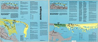
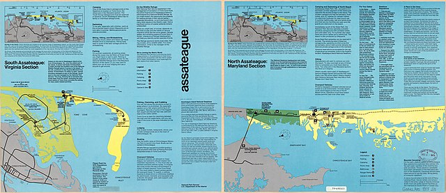
English: Scale ca. 1:33,000. Printed on both sides of sheet. Oriented with north toward the lower left. Covers Assateague Island National Seahore. Includes text and 2 location maps. Available also through the Library of Congress Web site as a raster image. AACR2 |
||
| Title | Assateague | ||
| Shelf ID | G3842.A85 1977 .U5 | ||
| Date | |||
| Source | https://www.loc.gov/item/79690323/ | ||
| Author | United States. National Park Service | ||
| Permission (Reusing this file) |
|
||
| Other versions |
|
||
| Location | United States · Assateague Island National Seashore. · Assateague Island National Seashore · Maryland · Virginia | ||
| Part of | American Memory · General Maps · Catalog · Geography And Map Division | ||
| Subject | Assateague Island National Seashore · Assateague Island National Seashore (Md. And Va.) · Virginia · United States · Maps · Maryland |

Licensing edit
| This image or media file contains material based on a work of a National Park Service employee, created as part of that person's official duties. As a work of the U.S. federal government, such work is in the public domain in the United States. See the NPS website and NPS copyright policy for more information. |
File history
Click on a date/time to view the file as it appeared at that time.
| Date/Time | Thumbnail | Dimensions | User | Comment | |
|---|---|---|---|---|---|
| current | 10:33, 20 May 2018 | | 9,812 × 4,242 (8.17 MB) | Fæ (talk | contribs) | LOC Maps https://www.loc.gov/item/79690323/ #181 |
You cannot overwrite this file.
File usage on Commons
The following page uses this file: