File:Assyria 1130-606 BC.png

Size of this preview: 659 × 599 pixels. Other resolutions: 264 × 240 pixels | 528 × 480 pixels | 718 × 653 pixels.
Original file (718 × 653 pixels, file size: 1,005 KB, MIME type: image/png)
Captions
Captions
Add a one-line explanation of what this file represents
Summary edit
| Description |
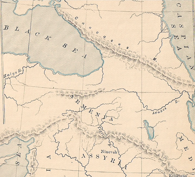
English: This is a map showing Assyria’s capital was on the Tigris river. So this illustration looks more professional, I decided to scan the map from the book (which was published in 1890). The book says Assyria ended in about 606 B.C. |
| Date | This map was created in 1890; this file was created on 22 December 2009 |
| Source | A General History for Colleges and High Schools by P. V. N. Myers |
| Author | Chuck Marean scanned the book and made this file. |
Licensing edit
This media file is in the public domain in the United States. This applies to U.S. works where the copyright has expired, often because its first publication occurred prior to January 1, 1929, and if not then due to lack of notice or renewal. See this page for further explanation.
|
 | |
 |
This image might not be in the public domain outside of the United States; this especially applies in the countries and areas that do not apply the rule of the shorter term for US works, such as Canada, Mainland China (not Hong Kong or Macao), Germany, Mexico, and Switzerland. The creator and year of publication are essential information and must be provided. See Wikipedia:Public domain and Wikipedia:Copyrights for more details.
|
File history
Click on a date/time to view the file as it appeared at that time.
| Date/Time | Thumbnail | Dimensions | User | Comment | |
|---|---|---|---|---|---|
| current | 19:24, 22 December 2009 | | 718 × 653 (1,005 KB) | Chuck Marean (talk | contribs) | {{Information |description={{en|This is a map showing Assyria’s capital was on the Tigris river. So this illustration looks more professional, I decided to scan the map from the book (which was published in 1890).}} |date=This map was created in {{1890} |
You cannot overwrite this file.
File usage on Commons
There are no pages that use this file.