File:Ataturk Landsat7 03272000.jpg
Size of this preview: 464 × 599 pixels. Other resolutions: 186 × 240 pixels | 505 × 652 pixels.
Original file (505 × 652 pixels, file size: 116 KB, MIME type: image/jpeg)
Captions
Captions
Add a one-line explanation of what this file represents
Summary
edit
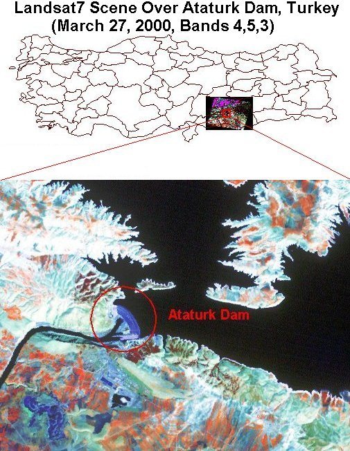
| Description | Water from the Ataturk dam and reservoir will irrigate a total of 882,000 hectares of which the Sanliurfa tunnel system will deliver water via gravity-flow to nearly 476,000 hectares onto the Sanliurfa-Harran, Mardin and Ceylanpinar plains. The Sanliurfa-Harran, Mardin and Ceylanpinar plains lie between the Euphrates and Tigris rivers, which encompass the famous "Fertile Crescent" -- the birthplace of the Mesopotamian civilizations and agriculture in the Middle East. |
| Date | |
| Source |
http://www.fas.usda.gov/pecad2/highlights/2001/08/turkey_gap/pictures/turkey_gap.htm (direct link)
|
| Author | NASA |
Licensing
edit
| This file is in the public domain in the United States because it was solely created by NASA. NASA copyright policy states that "NASA material is not protected by copyright unless noted". (See Template:PD-USGov, NASA copyright policy page or JPL Image Use Policy.) | ||
 |
Warnings:
|
Original upload log
edit
The original description page was here. All following user names refer to en.wikipedia.
- 2005-04-23 01:40 White Cat 505×652×8 (118449 bytes) {{PD-USGov-NASA}}
File history
Click on a date/time to view the file as it appeared at that time.
| Date/Time | Thumbnail | Dimensions | User | Comment | |
|---|---|---|---|---|---|
| current | 10:46, 15 May 2008 | | 505 × 652 (116 KB) | File Upload Bot (Magnus Manske) (talk | contribs) | {{BotMoveToCommons|en.wikipedia}} {{Information |Description={{en|Source: http://www.fas.usda.gov/pecad2/highlights/2001/08/turkey_gap/pictures/turkey_gap.htm ([http://www.fas.usda.gov/pecad2/highlights/2001/08/Turkey_Crop_Tour_files/ataturk/ataturk_Land |
You cannot overwrite this file.
File usage on Commons
There are no pages that use this file.
File usage on other wikis
The following other wikis use this file:
- Usage on en.wikipedia.org
- Usage on fa.wikipedia.org
- Usage on id.wikipedia.org