File:Atlas of the City of Quincy, 1923 - Plate 7.png

Size of this preview: 800 × 556 pixels. Other resolutions: 320 × 222 pixels | 640 × 445 pixels | 1,024 × 712 pixels | 1,280 × 890 pixels | 2,560 × 1,780 pixels | 3,500 × 2,433 pixels.
Original file (3,500 × 2,433 pixels, file size: 7.01 MB, MIME type: image/png)
Captions
Captions
Add a one-line explanation of what this file represents
Summary edit
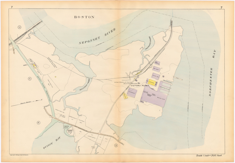
| Description |
English: A 1923 map of the Victory Plant, with the BERy streetcar loop and the New Haven Railroad's Victory Branch shown. |
|||
| Date | ||||
| Source | Atlas of the City of Quincy, Plate 7 | |||
| Author | Ernest W. Branch | |||
| Permission (Reusing this file) |
|

File history
Click on a date/time to view the file as it appeared at that time.
| Date/Time | Thumbnail | Dimensions | User | Comment | |
|---|---|---|---|---|---|
| current | 07:30, 30 May 2020 | | 3,500 × 2,433 (7.01 MB) | Pi.1415926535 (talk | contribs) | {{Information |description ={{en|1=A 1923 map of the Victory Plant, with the BERy streetcar loop and the New Haven Railroad's Victory Branch shown.}} |date =1923 |source =[https://www.wardmaps.com/viewasset.php?aid=2893 Atlas of the City of Quincy], Plate 7 |author =Ernest W. Branch |permission ={{PD-scan|PD-US-expired}} }} Category:1923 in Massachusetts Category:1923 maps of the United States Category:1920s maps of Massachusetts [[Category:Squantum Po... |
You cannot overwrite this file.
File usage on Commons
There are no pages that use this file.