File:August 17, 1999 Izmit earthquake Yuvacik.jpg

Size of this preview: 403 × 599 pixels. Other resolutions: 161 × 240 pixels | 323 × 480 pixels | 1,004 × 1,492 pixels.
Original file (1,004 × 1,492 pixels, file size: 862 KB, MIME type: image/jpeg)
Captions
Captions
Add a one-line explanation of what this file represents
Summary edit
| Description |
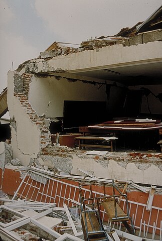
English: Yuvacik is south of Izmit and east of Golcuk. It was almost on top of the epicenter. The fault passes beneath this primary school building at Yuvacik. The permanent offset at this location is about one meter. The building is reinforced concrete frame construction with brick infill walls. Note that the brick walls do not seem to be joined at the corner. Children taking cover under the table would have been protected from injury. |
| Date | |
| Source | https://www.ngdc.noaa.gov/hazardimages/#/earthquake/23 |
| Author | NOAA National Geophysical Data Center |
Licensing edit
This image is in the public domain because it contains materials that originally came from the U.S. National Oceanic and Atmospheric Administration, taken or made as part of an employee's official duties.
|
File history
Click on a date/time to view the file as it appeared at that time.
| Date/Time | Thumbnail | Dimensions | User | Comment | |
|---|---|---|---|---|---|
| current | 20:20, 10 September 2023 | | 1,004 × 1,492 (862 KB) | Kurmanbek (talk | contribs) | Uploaded a work by NOAA National Geophysical Data Center from https://www.ngdc.noaa.gov/hazardimages/#/earthquake/23 with UploadWizard |
You cannot overwrite this file.
File usage on Commons
The following page uses this file:
File usage on other wikis
The following other wikis use this file:
- Usage on en.wikipedia.org
- Usage on tr.wikipedia.org