File:Aurignacian culture map-fr.svg

Size of this PNG preview of this SVG file: 720 × 540 pixels. Other resolutions: 320 × 240 pixels | 640 × 480 pixels | 1,024 × 768 pixels | 1,280 × 960 pixels | 2,560 × 1,920 pixels.
Original file (SVG file, nominally 720 × 540 pixels, file size: 90 KB)
Captions
Captions
Add a one-line explanation of what this file represents
Summary edit
| Description |
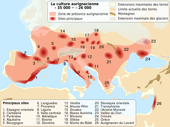
English: Location map of Homo Sapiens Aurignacian culture, between 37,000 and 28,000 BP. French version.
Français : Carte de localisation de la culture Homo Sapiens de l'Aurignacien, il y a entre 37 000 et 28 000 ans. |
||
| Date | (UTC) | ||
| Source | |||
| Author |
|
||
| Other versions |
Derivative works of this file: Aurignacian culture map-de.svg | ||
| Attribution (required by the license) | © Sémhur / Wikimedia Commons / | ||
| SVG | W3C-validity not checked.
|
||
| Graphic Lab |

| Camera location | | View this and other nearby images on: OpenStreetMap |
|---|
Licensing edit
I, the copyright holder of this work, hereby publish it under the following licenses:
| Copyleft: This work of art is free; you can redistribute it and/or modify it according to terms of the Free Art License. You will find a specimen of this license on the Copyleft Attitude site as well as on other sites. |
This file is licensed under the Creative Commons Attribution-Share Alike 4.0 International, 3.0 Unported, 2.5 Generic, 2.0 Generic and 1.0 Generic license.
- You are free:
- to share – to copy, distribute and transmit the work
- to remix – to adapt the work
- Under the following conditions:
- attribution – You must give appropriate credit, provide a link to the license, and indicate if changes were made. You may do so in any reasonable manner, but not in any way that suggests the licensor endorses you or your use.
- share alike – If you remix, transform, or build upon the material, you must distribute your contributions under the same or compatible license as the original.
You may select the license of your choice.
Original upload log edit
This image is a derivative work of the following images:
- File:Carte_Neandertaliens_classiques.svg licensed with Cc-by-sa-2.5,2.0,1.0, Cc-by-sa-3.0-migrated, GFDL
- 2007-03-27T13:56:40Z 120 824x535 (323284 Bytes) == Description == {{Information |Description= map of main sites where classical Neandertal fossil where found |Source= own work |Date= 27/03/2007 |Author= [[User:120]] |Permission= |other_versions= [[:Image:Carte Neandertalie
- 2007-03-27T13:51:28Z 120 824x535 (897152 Bytes) {{Information |Description= map of main sites where classical Neandertal fossil where found |Source= own work |Date= 27/03/2007 |Author= [[User:120]] |Permission= |other_versions= [[:Image:Carte Neandertaliens.jpg]] }}
Uploaded with derivativeFX
File history
Click on a date/time to view the file as it appeared at that time.
| Date/Time | Thumbnail | Dimensions | User | Comment | |
|---|---|---|---|---|---|
| current | 09:59, 26 May 2014 | | 720 × 540 (90 KB) | Sémhur (talk | contribs) | Valid SVG |
| 19:50, 28 October 2009 |  | 720 × 540 (91 KB) | Sémhur (talk | contribs) | == {{int:filedesc}} == {{Information |Description= {{en|Location map of Homo Sapiens Aurignacian culture, between 37,000 and 28,000 BP. French version.}} {{fr|Carte de localisation de la culture Homo Sapiens de l'[[:en:Aurignacien|Auri |
You cannot overwrite this file.
File usage on Commons
The following page uses this file:
File usage on other wikis
The following other wikis use this file:
- Usage on bg.wikipedia.org
- Usage on br.wikipedia.org
- Usage on cs.wikipedia.org
- Usage on en.wikipedia.org
- Usage on eo.wikipedia.org
- Usage on fi.wikipedia.org
- Usage on fr.wikipedia.org
- Usage on he.wikipedia.org
- Usage on hr.wikipedia.org
- Usage on hu.wikipedia.org
- Usage on hy.wikipedia.org
- Usage on lt.wikipedia.org
- Usage on nl.wikipedia.org
- Usage on ru.wikipedia.org
- Usage on tr.wikipedia.org
- Usage on uk.wikipedia.org
- Usage on vi.wikipedia.org