File:Automobile road from Los Angeles to Turnbull Canyon and return, 1919 (AAA-SM-004709).jpg

Size of this preview: 800 × 280 pixels. Other resolutions: 320 × 112 pixels | 640 × 224 pixels | 1,024 × 359 pixels | 1,280 × 448 pixels | 2,560 × 897 pixels | 6,200 × 2,172 pixels.
Original file (6,200 × 2,172 pixels, file size: 2.65 MB, MIME type: image/jpeg)
Captions
Captions
Add a one-line explanation of what this file represents
Summary edit
.jpg&action=edit§ion=1)
| Description |
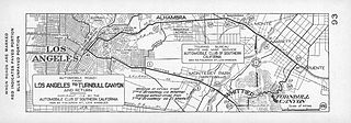
English: Automobile road from Los Angeles to Turnbull Canyon and return, 1919
|
| Date | |
| Source | http://digitallibrary.usc.edu/cdm/ref/collection/p15799coll59/id/341 |
| Author | Unknown author |
Licensing edit
.jpg&action=edit§ion=2)
This media file is in the public domain in the United States. This applies to U.S. works where the copyright has expired, often because its first publication occurred prior to January 1, 1929, and if not then due to lack of notice or renewal. See this page for further explanation.
|
 | |
 |
This image might not be in the public domain outside of the United States; this especially applies in the countries and areas that do not apply the rule of the shorter term for US works, such as Canada, Mainland China (not Hong Kong or Macao), Germany, Mexico, and Switzerland. The creator and year of publication are essential information and must be provided. See Wikipedia:Public domain and Wikipedia:Copyrights for more details.
|
File history
Click on a date/time to view the file as it appeared at that time.
| Date/Time | Thumbnail | Dimensions | User | Comment | |
|---|---|---|---|---|---|
| current | 11:18, 31 January 2014 | 6,200 × 2,172 (2.65 MB) | Fæ (talk | contribs) | == {{int:filedesc}} == {{Information |description={{en|1=<br> :''Automobile road from Los Angeles to Turnbull Canyon and return, 1919 :Strip map of automobile routes between Los Angeles and Turnbull Canyon including Whittier Boulevard and El Monte Road... |
You cannot overwrite this file.
File usage on Commons
There are no pages that use this file.
.jpg&oldid=808694077)