File:Map Alexander von Humboldt expedition-de.png
(Redirected from File:AvHumboldts Amerikareise map de.png)

Size of this preview: 800 × 535 pixels. Other resolutions: 320 × 214 pixels | 640 × 428 pixels | 1,024 × 685 pixels | 1,280 × 856 pixels | 2,844 × 1,903 pixels.
Original file (2,844 × 1,903 pixels, file size: 674 KB, MIME type: image/png)
Captions
Captions
Add a one-line explanation of what this file represents
Summary edit
| Description |
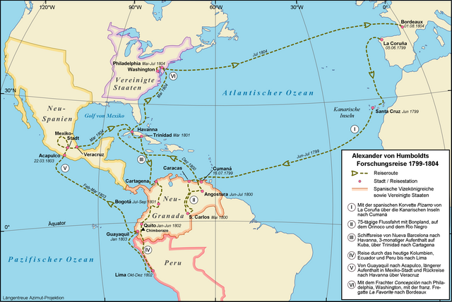
Deutsch: Amerikanische Forschungsreise des Alexander von Humboldt, 1799-1804
English: Alexander von Humboldt's American expedition from 1799-1804 |
| Date | |
| Source |
Own work
|
| Author | Alexrk |
| Permission (Reusing this file) |
Creative Commons : share alike - attribution required |
| Other versions |
[]
|


|
This map results from a map request to the Kartenwünsche in the Kartenwerkstatt. You can make as well a request for a new map.
|

|
File:Map Alexander von Humboldt expedition-de.svg is a vector version of this file. It should be used in place of this PNG file when not inferior.
File:Map Alexander von Humboldt expedition-de.png → File:Map Alexander von Humboldt expedition-de.svg
For more information, see Help:SVG. |
 |
Licensing edit
I, the copyright holder of this work, hereby publish it under the following license:
This file is licensed under the Creative Commons Attribution-Share Alike 2.5 Generic license.
- You are free:
- to share – to copy, distribute and transmit the work
- to remix – to adapt the work
- Under the following conditions:
- attribution – You must give appropriate credit, provide a link to the license, and indicate if changes were made. You may do so in any reasonable manner, but not in any way that suggests the licensor endorses you or your use.
- share alike – If you remix, transform, or build upon the material, you must distribute your contributions under the same or compatible license as the original.
File history
Click on a date/time to view the file as it appeared at that time.
| Date/Time | Thumbnail | Dimensions | User | Comment | |
|---|---|---|---|---|---|
| current | 09:08, 7 July 2009 | | 2,844 × 1,903 (674 KB) | Cäsium137~commonswiki (talk | contribs) | repair border |
| 09:01, 7 July 2009 |  | 2,844 × 1,862 (670 KB) | Cäsium137~commonswiki (talk | contribs) | printable scale | |
| 16:42, 28 May 2009 |  | 1,200 × 803 (376 KB) | Alexrk (talk | contribs) | Daten berichtigt | |
| 14:44, 3 April 2008 |  | 1,200 × 803 (376 KB) | Alexrk (talk | contribs) | Reiseroute anhand Koordinaten aus AvH Reisejournal verändert | |
| 13:16, 21 March 2008 |  | 1,200 × 803 (377 KB) | Alexrk (talk | contribs) | ||
| 16:03, 19 March 2008 |  | 1,200 × 803 (372 KB) | Alexrk (talk | contribs) | {{Information |Description={{de|Amerikanische Forschungsreise des Alexander von Humboldt, 1799-1804}} {{en|Alexander von Humboldt's American expedition from 1799-1804}} |Source=Own work<br/>Topographic map: vmap0 (Vector Map Level 0), Dates and Positions: |
You cannot overwrite this file.
File usage on Commons
The following 8 pages use this file:
- File:AvHumboldts Americatravel map zh.svg
- File:AvHumboldts Amerikareise map de.png (file redirect)
- File:Map Alexander von Humboldt expedition-de.png
- File:Map Alexander von Humboldt expedition-de.svg
- File:Map Alexander von Humboldt expedition-en.svg
- File:Map Alexander von Humboldt expedition-fr.svg
- File:Map Alexander von Humboldt expedition-mk.svg
- Template:Other versions/Map Alexander von Humboldt expedition
File usage on other wikis
The following other wikis use this file:
- Usage on de.wikipedia.org
- Usage on fr.wikiversity.org
- Usage on hu.wikipedia.org
- Usage on no.wikipedia.org
- Usage on sv.wikipedia.org