File:BD Narsingdi District locator map.svg

Size of this PNG preview of this SVG file: 441 × 600 pixels. Other resolutions: 176 × 240 pixels | 353 × 480 pixels | 565 × 768 pixels | 753 × 1,024 pixels | 1,506 × 2,048 pixels | 1,129 × 1,535 pixels.
Original file (SVG file, nominally 1,129 × 1,535 pixels, file size: 1.64 MB)
Captions
Captions
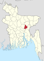
Location map of Narsingdi District in Bangladesh (Red)
Summary
edit
| Description |
বাংলা: বাংলাদেশে নরসিংদী জেলার অবস্থান। English: Narsingdi District in Bangladesh |
| Date | |
| Source | Own work |
| Author | Nafsadh |
| SVG development | This map was created with Adobe Illustrator. |
Licensing
edit
I, the copyright holder of this work, hereby publish it under the following license:
This file is licensed under the Creative Commons Attribution-Share Alike 4.0 International license.
- You are free:
- to share – to copy, distribute and transmit the work
- to remix – to adapt the work
- Under the following conditions:
- attribution – You must give appropriate credit, provide a link to the license, and indicate if changes were made. You may do so in any reasonable manner, but not in any way that suggests the licensor endorses you or your use.
- share alike – If you remix, transform, or build upon the material, you must distribute your contributions under the same or compatible license as the original.
File history
Click on a date/time to view the file as it appeared at that time.
| Date/Time | Thumbnail | Dimensions | User | Comment | |
|---|---|---|---|---|---|
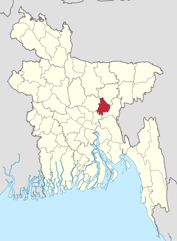
| current | 06:47, 4 November 2021 | | 1,129 × 1,535 (1.64 MB) | C1MM (talk | contribs) | updated bounds |
| 09:15, 23 February 2016 |  | 1,550 × 2,150 (81 KB) | NordNordWest (talk | contribs) | upd | |
| 02:03, 25 October 2014 |  | 1,550 × 2,150 (80 KB) | Nafsadh (talk | contribs) | User created page with UploadWizard |
You cannot overwrite this file.
File usage on Commons
The following 2 pages use this file:
File usage on other wikis
The following other wikis use this file:
- Usage on bn.wikipedia.org
- নরসিংদী জেলা
- বেলাবো উপজেলা
- মনোহরদী উপজেলা
- শিবপুর উপজেলা
- রায়পুরা উপজেলা
- নরসিংদী সদর উপজেলা
- পলাশ উপজেলা
- টেমপ্লেট:নরসিংদী জেলা
- ব্যবহারকারী:রাতুল
- টেমপ্লেট:ব্যবহারকারী/নরসিংদী জেলা
- মির্জাপুর ইউনিয়ন, রায়পুরা
- বাংলাদেশের জেলাসমূহের তালিকা
- চালাকচর ইউনিয়ন
- খিদিরপুর ইউনিয়ন
- লেবুতলা ইউনিয়ন, মনোহরদী
- বড়চাপা ইউনিয়ন
- কাচিকাটাঁ ইউনিয়ন
- গোতাশিয়া ইউনিয়ন
- শুকুন্দি ইউনিয়ন
- চরমান্দালিয়া ইউনিয়ন
- একদুরিয়া ইউনিয়ন
- বাঘাব ইউনিয়ন
- নরসিংদী পৌরসভা
- করিমপুর ইউনিয়ন, নরসিংদী সদর
- কাঁঠালিয়া ইউনিয়ন, নরসিংদী সদর
- হাজীপুর ইউনিয়ন, নরসিংদী সদর
- শিলমান্দি ইউনিয়ন
- চিনিশপুর ইউনিয়ন
- মেহেরপাড়া ইউনিয়ন
- পাঁচদোনা ইউনিয়ন
- আমদিয়া ইউনিয়ন
- নূরালাপুর ইউনিয়ন
- পাইকারচর ইউনিয়ন
- মহিষাশুরা ইউনিয়ন
- নজরপুর ইউনিয়ন
- আলোকবালী ইউনিয়ন
- চরদিঘলদী ইউনিয়ন
- রায়পুরা পৌরসভা
- শিবপুর পৌরসভা
- মনোহরদী পৌরসভা
- মির্জারচর ইউনিয়ন
- মরজাল ইউনিয়ন
- রায়পুরা ইউনিয়ন
- বাঁশগাড়ি ইউনিয়ন
- পলাশতলী ইউনিয়ন
- পাড়াতলী ইউনিয়ন
- আদিয়াবাদ ইউনিয়ন
- হাইরমারা ইউনিয়ন
- চরমুধুয়া ইউনিয়ন
- শ্রীনগর ইউনিয়ন, রায়পুরা
View more global usage of this file.