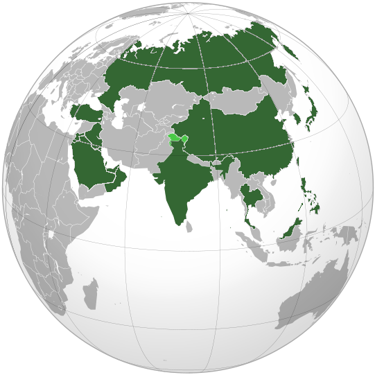
File:BK Asia (orthographic projection).png
BK_Asia_(orthographic_projection).png (541 × 541 pixels, file size: 110 KB, MIME type: image/png)
Captions
Captions
| DescriptionBK Asia (orthographic projection).png |
English: Map of countries in Asia Burger King locations (orthographic projection) |
| Date | (UTC) |
| Source | |
| Author |
| This is a retouched picture, which means that it has been digitally altered from its original version. Modifications: Modified image to produce a map of countries with Burger King locations in Asia. The original can be viewed here: India (orthographic projection).svg:
|
- You are free:
- to share – to copy, distribute and transmit the work
- to remix – to adapt the work
- Under the following conditions:
- attribution – You must give appropriate credit, provide a link to the license, and indicate if changes were made. You may do so in any reasonable manner, but not in any way that suggests the licensor endorses you or your use.
- share alike – If you remix, transform, or build upon the material, you must distribute your contributions under the same or compatible license as the original.

|
Permission is granted to copy, distribute and/or modify this document under the terms of the GNU Free Documentation License, Version 1.2 or any later version published by the Free Software Foundation; with no Invariant Sections, no Front-Cover Texts, and no Back-Cover Texts. A copy of the license is included in the section entitled GNU Free Documentation License.http://www.gnu.org/copyleft/fdl.htmlGFDLGNU Free Documentation Licensetruetrue |
The map has been created with the Generic Mapping Tools: https://www.generic-mapping-tools.org/ using one or more of these public-domain datasets for the relief:
বাংলা ∙ English ∙ español ∙ français ∙ italiano ∙ 日本語 ∙ македонски ∙ sicilianu ∙ 中文(简体) ∙ 中文(繁體) ∙ +/− |

|
Permission is granted to copy, distribute and/or modify this document under the terms of the GNU Free Documentation License, Version 1.2 or any later version published by the Free Software Foundation; with no Invariant Sections, no Front-Cover Texts, and no Back-Cover Texts. A copy of the license is included in the section entitled GNU Free Documentation License.http://www.gnu.org/copyleft/fdl.htmlGFDLGNU Free Documentation Licensetruetrue |
Original upload log edit
This image is a derivative work of the following images:
- File:India_(orthographic_projection).svg licensed with Cc-by-sa-3.0, GFDL, GFDL-GMT
- 2009-11-15T23:40:34Z Shibo77 541x541 (587122 Bytes) +Eritrea, Yemen; -neutral zone
- 2009-11-01T13:18:32Z Pahari Sahib 541x541 (508157 Bytes) Map showing territory governered by India, see map of Pakistan
- 2009-03-11T13:17:49Z Tryphon 541x541 (585563 Bytes) Reverted to version as of 22:12, 13 February 2009: please use the talk page before reverting this image; there are apparently many people who want the map this way.
- 2009-03-11T12:34:03Z Pahari Sahib 541x541 (508157 Bytes) Reverted to version as of 22:08, 13 February 2009 (removing territory not part of India)
- 2009-02-13T22:12:20Z Dbachmann 541x541 (585563 Bytes) Reverted to version as of 15:27, 25 November 2008
- 2009-02-13T22:09:38Z Dbachmann 541x541 (585563 Bytes) Reverted to version as of 22:08, 13 February 2009
- 2009-02-13T22:08:46Z Dbachmann 541x541 (508157 Bytes) Reverted to version as of 09:27, 9 February 2009
- 2009-02-13T22:08:06Z Dbachmann 541x541 (585563 Bytes) Reverted to version as of 15:27, 25 November 2008. Earlier revert was probably in error, this is the npov version of the map called for on article talk
- 2009-02-09T09:27:09Z Tryphon 541x541 (508157 Bytes) Reverted to version as of 12:00, 25 November 2008: if you want a map of Pakistan, please upload it with another name
- 2008-11-25T15:27:42Z Shibo77 541x541 (585563 Bytes) {{Information |Description=.. |Source=.. |Date=.. |Author=Ssolbergj |Permission=.. |other_versions=.. }}
- 2008-11-25T12:00:40Z Deepak 541x541 (508157 Bytes) Reverted to version as of 02:20, 3 November 2008 == if someone wants to mark PoK, then please do so properly and to scale instead of ruining the entire map
- 2008-11-24T03:12:10Z Shibo77 541x541 (514671 Bytes) {{Information |Description=.. |Source=.. |Date=.. |Author=Ssolbergj |Permission=.. |other_versions=.. }}
- 2008-11-03T02:20:37Z Ssolbergj 541x541 (508157 Bytes) {{Information |Description={{en|1=India}} |Source=Own work, {{Inkscape}}[http://www.aquarius.geomar.de/omc/make_map.html Aquarius.geomar.de]{{GFDL-GMT}} |Author=~~~ |Date= November 2008 |Permission= |other_versions={{User:Sso
Uploaded with derivativeFX
File history
Click on a date/time to view the file as it appeared at that time.
| Date/Time | Thumbnail | Dimensions | User | Comment | |
|---|---|---|---|---|---|
| current | 23:58, 17 August 2016 |  | 541 × 541 (110 KB) | फ़िलप्रो (talk | contribs) | Reverted to version as of 04:29, 30 January 2011 (UTC) |
| 20:19, 11 January 2014 |  | 541 × 541 (103 KB) | Nattynab (talk | contribs) | Added Pakistan. Removed India - Plans to open a branch does not mean a branch is already present. | |
| 04:29, 30 January 2011 |  | 541 × 541 (110 KB) | Jerem43 (talk | contribs) | {{Information |Description ={{en|1=Map of countries in Asia Burger King locations (orthographic projection)}} |Source = *File:India (orthographic projection).svg |Date =2011-01-30 04:28 (UTC) |Author = *[[:File:India (orthographic p |
You cannot overwrite this file.
File usage on Commons
There are no pages that use this file.
Metadata
This file contains additional information such as Exif metadata which may have been added by the digital camera, scanner, or software program used to create or digitize it. If the file has been modified from its original state, some details such as the timestamp may not fully reflect those of the original file. The timestamp is only as accurate as the clock in the camera, and it may be completely wrong.
| Horizontal resolution | 37.8 dpc |
|---|---|
| Vertical resolution | 37.8 dpc |
| File change date and time | 23:40, 15 November 2009 |
