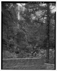
File:BRIDGE DETAIL AND BRIDALVEIL FALLS. - Bridalveil Fall Bridge No. 3, Spanning Bridalveil Creek on carriage road, Yosemite Village, Mariposa County, CA HAER CAL,22-YOSEM,9-5.tif

Size of this JPG preview of this TIF file: 480 × 599 pixels. Other resolutions: 192 × 240 pixels | 384 × 480 pixels | 615 × 768 pixels | 820 × 1,024 pixels | 1,641 × 2,048 pixels | 4,006 × 5,000 pixels.
Original file (4,006 × 5,000 pixels, file size: 19.1 MB, MIME type: image/tiff)
Captions
Captions
Add a one-line explanation of what this file represents
Summary edit
| BRIDGE DETAIL AND BRIDALVEIL FALLS. - Bridalveil Fall Bridge No. 3, Spanning Bridalveil Creek on carriage road, Yosemite Village, Mariposa County, CA | ||||
|---|---|---|---|---|
| Photographer |
Grogan, Brian C. Related names:
|
|||
| Title |
BRIDGE DETAIL AND BRIDALVEIL FALLS. - Bridalveil Fall Bridge No. 3, Spanning Bridalveil Creek on carriage road, Yosemite Village, Mariposa County, CA |
|||
| Depicted place | California; Mariposa County; Yosemite Village | |||
| Date | 1991 | |||
| Dimensions | 4 x 5 in. | |||
| Current location |
Library of Congress Prints and Photographs Division Washington, D.C. 20540 USA http://hdl.loc.gov/loc.pnp/pp.print |
|||
| Accession number |
HAER CAL,22-YOSEM,9-5 |
|||
| Credit line |
|
|||
| Notes |
|
|||
| Source | https://www.loc.gov/pictures/item/ca1640.photos.041758p | |||
| Permission (Reusing this file) |
|
|||

| Object location | | View this and other nearby images on: OpenStreetMap |
|---|
File history
Click on a date/time to view the file as it appeared at that time.
| Date/Time | Thumbnail | Dimensions | User | Comment | |
|---|---|---|---|---|---|
| current | 04:11, 4 July 2014 |  | 4,006 × 5,000 (19.1 MB) | Fæ (talk | contribs) | GWToolset: Creating mediafile for Fæ. HABS batch upload 2 July 2014 (301:400) |
You cannot overwrite this file.
File usage on Commons
The following page uses this file: