File:BTC-Pipeline.png

Original file (2,766 × 1,876 pixels, file size: 5.49 MB, MIME type: image/png)
Captions
Captions
Summary
edit
| Description |
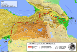
Deutsch: Lage der BTC-Pipeline LicensingProjektionsmethodeKartenbegrenzungen
Code für GMTGlobe-Daten vorbereiten zur Verarbeitungxyz2grd g10g -R0/90/0/50 -I30c -ZTLh -F -N-500 -Gg10g.grd Globe-Datei in *.grd Datei umwandeln grdcut g10g.grd -R25/25/55/50r -Gbtc.grd ausschneiden der relevanten Region (dabei den Kartenausschnitt ein bisle größer gehalten) grdgradient btc.grd -A135 -Ne0.2 -Gbtc_schatten.grd Schatten erstellt Farbtabelle für die Topographie#btc.cpt -571842740023621883 40023621883400013510331 B137175252 F255255255 N137175252 ein kleines bisle abgewandelt bei B und N damit ich mir viel nacharbeiten erspare grd2cpt btc.grd -Cbtc.cpt -R34/34/52/44r -S0/4000/50 >btc_1.cpt erstellen der endgültigen Farbtabelle Topographische Karte erstellenpscoast -JA43/39/24c -R34/34/52/44r -G137/175/252 -S137/175/252 -Df -P -K --PAPER_MEDIA=A3 >btc_topo.ps erstellt eine Karte in der Land- und Meeresflächen den gleichen Blauton haben (in dem Fall ganz praktisch) pscoast -Gc -JA43/39/24c -R34/34/52/44r -Df -O -P -K --PAPER_MEDIA=A3 >>btc_topo.ps wählt für den nächsten Bearbeitungsschritt nur die Landflächen aus grdimage btc.grd -Ibtc_schatten.grd -Cbtc_1.cpt -JA43/39/24c -R34/34/52/44r --PAPER_MEDIA=A3 -P -O -K >>btc_topo.ps erstellt aus den Globe-Daten, der Farbtabelle und der Schattendatei eine topographische Karte (allerdings nur in dem ausgewähltem Bereich, sprich Land) pscoast -JA43/39/24c -R34/34/52/44r -Q -O >>btc_topo.ps hebt die Auswahl wieder auf (wichtig!!!) ps2raster -A -Tg -Gc:\programme\gs\gs8.60\bin\gswin32c btc_topo.ps gibt eine png-Datei aus Globus erstellenpscoast -Rg -JA43/30/18c -B15g15 -Df -P -A0/0/100000 -S200/200/200 -Gblack >btc_earth.ps die Werte für -A (also die Genauigkeit für Inseln und Seen) sind nicht optimal, ich hab aber auf die schnelle keine besseren parat gehabt. Problem: möglichst alle Inseln aber nur die größten Seen sollten erscheinen ps2raster -A -Tg -Gc:\programme\gs\gs8.60\bin\gswin32c btc_earth.ps gibt eine png-Datei aus Rest |
| Date | |
| Source |
Transferred from de.wikipedia to Commons.
|
| Author | mario |
![[1]](http://www.de.sgs.com/de/bild2-2.jpg)
![[2]](http://www.deutschebp.de/liveassets/bp_internet/germany/STAGING/home_assets/images/karten/btc_pipeline_kartenausschnitt_375xx.jpg)
![[3]](http://home.arcor.de/geonebil/stgeorghilfe/images/tectonic1.jpg)
![[4]](http://www.gfz-potsdam.de/news/foto/tuerkei/Erdbeb.gif)
![[5]](http://141.84.51.10/palmuc/sammlung_geologie/seiten/museum/geoforum/erdbeben/Anatolien2.gif)
Licensing
edit

|
Permission is granted to copy, distribute and/or modify this document under the terms of the GNU Free Documentation License, Version 1.2 or any later version published by the Free Software Foundation; with no Invariant Sections, no Front-Cover Texts, and no Back-Cover Texts. A copy of the license is included in the section entitled GNU Free Documentation License. |
| This file is licensed under the Creative Commons Attribution-Share Alike 3.0 Unported license. | ||
| Attribution: Devil m25 | ||
| ||
| This licensing tag was added to this file as part of the GFDL licensing update. |
Original upload log
edit
- 2008-05-30 09:51 Devil m25 2766×1876× (5754281 bytes)
- 2008-05-28 09:41 Devil m25 2764×1872× (6128772 bytes) ergänzt
- 2008-05-26 09:45 Devil m25 1841×1252× (3462105 bytes) {{Information |Beschreibung = Lage der BTC-Pipeline |Quelle = selbst erstellt |Urheber = |Datum = 05/2008 |Genehmigung = |Andere Versionen = |Anmerkungen = }}
File history
Click on a date/time to view the file as it appeared at that time.
| Date/Time | Thumbnail | Dimensions | User | Comment | |
|---|---|---|---|---|---|
| current | 10:57, 5 October 2010 | | 2,766 × 1,876 (5.49 MB) | Antemister (talk | contribs) | {{Information |Description={{de|Lage der BTC-Pipeline<br/> == Lizenz: == == Projektionsmethode == * de:Flächentreue Azimutalprojektion === Kartenbegrenzungen === * 34 bis 52 Ö.L. * 34 bis 44 n.B. * '' |
You cannot overwrite this file.
File usage on Commons
The following page uses this file:
File usage on other wikis
The following other wikis use this file:
- Usage on ar.wikipedia.org
- Usage on de.wikipedia.org
- Usage on en.wikiquote.org
- Usage on ga.wikipedia.org
- Usage on he.wikipedia.org
- Usage on ka.wikipedia.org
- Usage on lv.wikipedia.org
- Usage on nl.wikipedia.org
- Usage on ru.wikipedia.org
- Usage on ru.wikinews.org
- Usage on uk.wikipedia.org
- Usage on www.wikidata.org