File:BTTR southernmost positions.png
(Redirected from File:BTTR southernmost positions.gif)
BTTR_southernmost_positions.png (387 × 269 pixels, file size: 13 KB, MIME type: image/png)
File information
Structured data
Captions
Captions
Add a one-line explanation of what this file represents
Summary edit
| DescriptionBTTR southernmost positions.png |
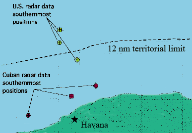
English: The map shows the southernmost locations according to US and Cuban data of the three planes flown by en:Brothers to the Rescue on February 24, 1996, prior to two of them being shot down by a Cuban MIG.
Map is redrawn and adapted from maps and information in ICAO: "Report on the shooting down of two U.S.-registered private civil aircraft by Cuban military aircraft on 24 February 1996", C-WP/10441, June 20, 1996, United Nations Security Council document, S/1996/509, July 1, 1996, [1] |
| Date | 20 January 2007 (original upload date) |
| Source | Transferred from en.wikipedia to Commons by Escla using CommonsHelper. |
| Author | Jensbn at English Wikipedia |
Licensing edit
| Public domainPublic domainfalsefalse |
| This work has been released into the public domain by its author, Jensbn at English Wikipedia. This applies worldwide. In some countries this may not be legally possible; if so: Jensbn grants anyone the right to use this work for any purpose, without any conditions, unless such conditions are required by law.Public domainPublic domainfalsefalse |
Original upload log edit
The original description page was here. All following user names refer to en.wikipedia.
- 2007-01-20 17:18 Jensbn 387×269×8 (12429 bytes) The map shows the southernmost locations according to US and Cuban data of the three planes flown by [[Brothers to the Rescue]] on February 24, 1996, prior to two of them being shot down by a Cuban MIG. Map is redrawn and adapted from maps and informatio
Original upload log edit
| Date/Time | Dimensions | User | Comment |
|---|---|---|---|
| 24 May 2008, 23:04:04 | 387 × 269 (12429 bytes) | File Upload Bot (Magnus Manske) (talk · contribs) | {{BotMoveToCommons|en.wikipedia}} {{Information |Description={{en|The map shows the southernmost locations according to US and Cuban data of the three planes flown by [[:en:Brothers to the Rescue]] on February 24, 1996, prior to two of them being shot do |
File history
Click on a date/time to view the file as it appeared at that time.
| Date/Time | Thumbnail | Dimensions | User | Comment | |
|---|---|---|---|---|---|
| current | 23:36, 21 August 2014 |  | 387 × 269 (13 KB) | GifTagger (talk | contribs) | Bot: Converting file to superior PNG file. (Source: BTTR_southernmost_positions.gif). This GIF was problematic due to non-greyscale color table. |
You cannot overwrite this file.
File usage on Commons
The following 2 pages use this file:
File usage on other wikis
The following other wikis use this file:
- Usage on ca.wikipedia.org
- Usage on de.wikipedia.org
- Usage on en.wikipedia.org
- Usage on ru.wikipedia.org
- Usage on www.wikidata.org
