File:Back Bay map 1902.PNG
No higher resolution available.
Back_Bay_map_1902.PNG (307 × 234 pixels, file size: 166 KB, MIME type: image/png)
Captions
Captions
Add a one-line explanation of what this file represents
| Description |
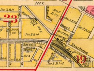
English: Detail of 1902 map of Boston, showing Back Bay Station on the New Haven mainline and Trinity Place and Huntington Avenue stations on the Boston & Albany Railroad. |
||
| Date | |||
| Source | 1902 Boston map from Ward Maps | ||
| Author | Unknown author | ||
| Permission (Reusing this file) |
|
File history
Click on a date/time to view the file as it appeared at that time.
| Date/Time | Thumbnail | Dimensions | User | Comment | |
|---|---|---|---|---|---|
| current | 03:15, 6 April 2012 | | 307 × 234 (166 KB) | Pi.1415926535 (talk | contribs) | Awkward rotation |
| 03:12, 6 April 2012 |  | 328 × 258 (241 KB) | Pi.1415926535 (talk | contribs) | {{Information |Description ={{en|1=Detail of 1902 map of Boston, showing Back Bay Station on the New Haven mainline and Trinity Place and Huntington Avenue stations on the Boston & Albany Railroad.}} |Source =[http://www.wardmaps.com/viewass... |
You cannot overwrite this file.
File usage on Commons
There are no pages that use this file.