File:Backens kyrka 1686.png

Size of this preview: 560 × 599 pixels. Other resolutions: 224 × 240 pixels | 448 × 480 pixels | 869 × 930 pixels.
Original file (869 × 930 pixels, file size: 384 KB, MIME type: image/png)
Captions
Captions
Add a one-line explanation of what this file represents
Summary
edit
| Description |
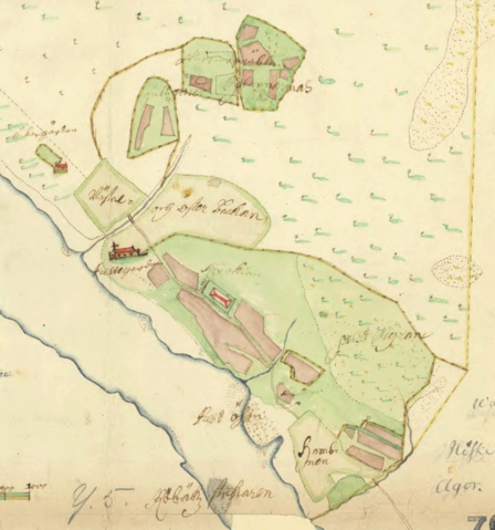
Svenska: Utsnitt ur geometrisk avmätning av Umeå sockens kyrkobord 1686. Upphovsman var troligen lantmätaren Jonas Persson Gedda. På kartan syns Backens kyrka vid Umeälvens norra strand och väster därom prästgården. Vid älven ligger Prästön och hamnen.
English: Part of map of the church estate of Umeå parish in 1686. The map was probably drawn by Jonas Persson Gedda. The map shows Backen's church on the north side of river Umeälven. To the west of the church is the rectory. Near the river is Prästön and the harbour. |
| Date | |
| Source | Historisk karta |
| Author | Jonas Persson Gedda |
| Camera location | | View this and other nearby images on: OpenStreetMap |
|---|
Licensing
edit
|
This work is in the public domain in its country of origin and other countries and areas where the copyright term is the author's life plus 100 years or fewer. | |
| This file has been identified as being free of known restrictions under copyright law, including all related and neighboring rights. | |
File history
Click on a date/time to view the file as it appeared at that time.
| Date/Time | Thumbnail | Dimensions | User | Comment | |
|---|---|---|---|---|---|
| current | 06:37, 10 September 2016 | | 869 × 930 (384 KB) | Skogsfrun (talk | contribs) | User created page with UploadWizard |
You cannot overwrite this file.
File usage on Commons
There are no pages that use this file.
File usage on other wikis
The following other wikis use this file:
- Usage on sv.wikipedia.org